

| Mapping Toolbox | |
Maps a country or region using the worldlo atlas data.
Syntax
worldmap
worldmap region
worldmap regiononly
worldmap(region,type)
worldmap(latlim,lonlim)
worldmap(latlim,lonlim,type)
worldmap(map,maplegend)
worldmap(map,maplegend,type)
worldmap(datasource,...)
Description
worldmap maps a region or country using the worldlo atlas data. The region is selected interactively from a list. The map is created in the current axes.
worldmap region or worldmap(region) makes a map of the specified region. Recognized region strings are 'Africa', 'Antarctica', 'Asia', 'Europe', 'North America','North Pole', 'Pacific', 'South America', 'South Pole', 'World' and the names of the countries in the worldlo atlas data. region may also be a padded string matrix or a cell array of strings containing multiple country names.
worldmap regiononly adds only the specified country to the map. For example, worldmap italyonly. If any of the country names in region string matrix or cell array of strings end with 'only', only the requested countries are displayed.
worldmap(regiononly,type) controls the atlas data displayed. Type 'line' or 'patch' creates a map with atlas data of those types. If the size of the map permits, point and text annotation of countries and cities is included. Type 'lineonly' or 'patchonly' suppresses the point and text annotation. Type 'none' suppresses all atlas data. If omitted, type 'line' is assumed.
worldmap(latlim,lonlim) and worldmap(latlim,lonlim,type) use the supplied geographic limits to define the map. The geographic limits are two-element vectors of the form [start end], in angular units of degrees.
worldmap(map,maplegend) and worldmap(map,maplegend,type) use the supplied regular matrix map to define the geographic limits. The matrix map is displayed using meshm unless type is 'none', 'lineonly', 'patch' or 'patchonly'. Use type 'meshonly' to display only the matrix map. Type 'mesh' and 'meshonly' display the matrix map as a colored surface in the z=0 plane with the default colormap. Type 'dem' and 'demonly' apply the digital elevation colormap. Type 'dem3d' and 'dem3donly' display a 3-dimensional surface. Type 'lmesh3d', 'lmesh3donly', 'ldem3d' and 'ldem3donly' apply lighting effects to the surfaces.
worldmap('hi',...) or worldmap('lo',...) enforces the use of high or low resolution data in the map. If omitted, worldmap will select the appropriate data set based on graphic scale. For small-scale maps (1:30,000,000 and under), the worldlo database is used. Above 1:30,000,000 (at larger scales), the worldhi database is used. When using the high resolution data, worldmap will not include islands smaller than an appropriate threshhold size. Use worldmap('allhi',...) to ensure that all islands are included, regardless of size.
h = worldmap(...) returns the handle of the map axes.
Example
worldmap 'south america'figure; worldmap france
figure; worldmap(`lo','franceonly','patch') displaym(worldlo(`POline'))
figure; worldmap([2 16],[-9 7],'patch');
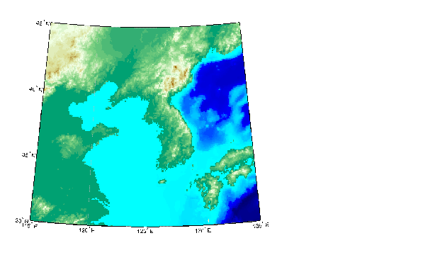
figure; load korea; worldmap(map,maplegend,'dem'); brighten(.5)
Remarks
worldmap uses tightmap to set the axis limits tight around the map. If you change the projection, or just want more white space around the map frame, use tightmap again or axis auto.
Use hidem(gca) to remove the axes box and hidem or clmo to remove other unwanted graphic objects. set(gca,'Color','w') makes the figure background white.
See Also
usamap |
Creates a map of the United States of America |
gridm |
Toggle and control the display of the map grid |
mlabel |
Meridian labels projected onto a map axes |
plabel |
Parallel labels projected onto a map axes |
framem |
Toggle and control the display of the map frame |
worldlo |
Returns data from the worldlo atlas data file |
worldhi |
Returns data from the worldhi atlas data file |
| | worldlo | yx2rc | |