| Mapping Toolbox | |
Return data from the 1:1,000,000 WORLDHI atlas data file.
Syntax
worldhi
s = worldhi(request)
s = worldhi(countryname,minarea)
s = worldhi(countryname,searchmethod)
s = worldhi(countryname,searchmethod,minarea)
s = worldhi(latlim,lonlim)
s = worldhi(latlim,lonlim,minarea)
Description
worldhi types a list of the atlas data variables in the worldhi MAT-file to the screens.
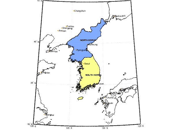
s = worldhi(request) returns the requested variable. Valid requests are 'POpatch', 'POtext', 'PPpoint', 'PPtext', and any country name in the worldhi database. Multiple countries can be requested by a string matrix or cell array of strings. The result is returned as a geographic data structure. This command can be used as an argument to other commands, such as displaym(worldhi('POtext')) or displaym(worldhi('france')). The worldhi database contains country outlines and text originally compiled at a scale of 1:1,000,000.
s = worldhi(countryname,minarea) removes small islands from the output. Only polygon faces with an area greater than minarea (in units of square kilometers) are returned.
s = worldhi(countryname,searchmethod) controls the method used to match the country name input. Search method 'strmatch' searches for matches at the beginning of the name, similar to the MATLAB strmatch function. Search method 'findstr' searches within the name, similar to the MATLAB findstr function. Search method 'exact' requires an exact match. If omitted, search method 'strmatch' is assumed. The search is not case-sensitive.
s = worldhi(countryname,searchmethod,minarea) controls both the minumum area and the string matching method.
s = worldhi(latlim,lonlim) returns all countries within a quadrangle. latlim and lonlim are two-element vectors in units of degrees positive or negative from the prime meridian. Islands or noncontiguous parts of the countries whose bounding boxes fall completely outside the requested region are omitted from the output.
s = worldhi(latlim,lonlim,minarea) also removes small islands from the output. Only polygon faces with an area greater than minarea (in units of square kilometers) are returned.
Example
Make a basemap map of the Korean peninsula using lines and display the two Koreas from the worldhi database.
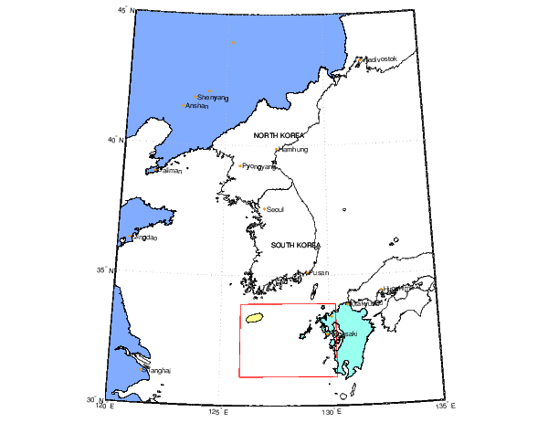
Delete the Korean patches, and display data from the worldhi database that falls within some geographic limits. Mainland China is displayed because its bounding box encompasses the requested quadrangle.
delete(h)

latlim = [31.1 33.9]';
lonlim = [125.9 130.3]';
lat = [latlim; flipud(latlim); latlim(1)];
lon = [lonlim(1); lonlim; flipud(lonlim)];
plotm(lat,lon,'r')

s = worldhi(latlim,lonlim,100);
h = displaym(s);
See Also
worldlo |
Return data from the worldlo atlas data file |
coast |
Return vector coastline data |
usahi |
Return data from the usahi atlas data file |
usalo |
Return data from the usalo atlas data file |
worldhi.mat |
worldhi atlas data MAT-file |
displaym |
Project data in a geographic data structure |
| | westof | worldlo | |