| Mapping Toolbox | |
Vector Map Level 0 (VMap0) user interface
Activation
vmap0ui
vmap0ui(devicename) or vmap0ui devicename
Description
vmap0ui is a graphical user interface to read Vector Map Level 0 CD-ROMs. The VMAP0 is the most detailed global database of vector map data available to the public. vmap0ui attempts to automatically detect which drive contains a VMAP0 CD-ROM. If vmap0ui can't find the CD, use the following calling form.
vmap0ui(devicename) or vmap0ui devicename uses the specified logical device name for the CD-ROM drive containing the VMAP0 CD-ROM. Under the Macintosh operating system, it would be 'VMAP'. Under the Windows OS, it could be 'f:' or 'g:' or some other letter. Under UNIX, it could be '\cdrom\'. Check your computer's documentation for the correct device name.
VMAP0 CD-ROMs are available from
USGS Information Services (Map and Book Sales)
Box 25286
Denver Federal Center
Denver, CO 80225
Telephone: (303) 202-4700
Fax: (303) 202-4693
The price as of early 1998 was $82.50 per four disk set.
Information on the VMAP0 data can be found at <http://164.214.2.54/mel/metadata/vmap0.meta.html>
Controls
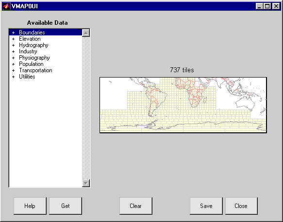
The vmap0ui screen lets you read data from the Vector Map Level 0 (VMAP0). The VMAP0 is the most detailed map database available to the public.
You use the list to select the type of data and the map to select the region of interest. When you click the Get button, data is extracted and displayed on the map. Use the Save button to save the data in a MAT-file or to the base workspace for later display. The Close button closes the window.
The Map controls the geographic extent of the data to be extracted. vmap0ui extracts data for areas currently visible on the map. Use the mouse to zoom in or out to the area of interest. Type HELP ZOOM for more on zooming.
The VMAP0 divides the world up into tiles of about 5 by 5 degrees. When extracting, data is returned for all visible tiles, including those parts of the tile that are outside of the current view. The map shows the VMAP0 tiles in light yellow with light gray edges. The data density is high, so extracting data for a large number of tiles may take much time and memory. A count of the number of visible tiles is above the map.
The List controls the type of data to be extracted. The tree structure of the list reflects the structure of the VMAP0 database. Upon starting vmap0ui, the list shows the major categories of VMAP data, called themes.Themes are subdivided into features, which consist of data of common graphic type (patch, line, point or text) or cultural type (airport, roads, railroads). Double-click on a theme to see the associated features. Features may have properties and values, for example a railroad tracks property, with values single or multiple. Double-click on a feature to see the associated properties and values. Double clicking on an open theme or feature will close it. When a theme is selected, vmap0ui will get all of the associated features. When a feature is selected, vmap0ui will get all of that feature data. When properties and values are selected, vmap0ui will get the data for any of the properties and values match (i.e., the union operation).
The Get button reads the currently selected VMAP0 data and displays it on the map. Use the Cancel button on the progress bar to interrupt the process. For a quicker response, press the standard interrupt key combination for your platform.
The Clear button removes any previously read data from the map.
The Save button saves the currently displayed VMAP0 data to a Mat-file or the base workspace. If you choose to save to a file, you will be prompted for a file name and location. If you choose to save to the base workspace, you will be notified of the variable names that will be overwritten. The results are stored as geographic data structures with variables names based on theme and feature names. Use load and displaym to redisplay the data from a file on a map axes. You can also use the mlayers GUI to read and display the data from a file. To display the data in the base workspace, use displaym. To display all of the geographic data structures, use rootlayr; displaym(ans). To display all of the geographic data structures using the mlayers GUI, type rootlayr; mlayers(ans).
The Close button closes the vmap0ui panel.
See Also
vmap0data mlayers displaym extractm
| | vmap0rhead | Bibliography | |