| Mapping Toolbox | |
Interactively display and control objects in a geographic data structure workspace
Activation
| Command Line |
Maptool |
mlayers(mlayers(cellarray)mlayers(cellarray,h) |
Session Layers Layers |
Description
The mlayers tool activates a dialog box for the specified geographic data structure workspace, which enables display and manipulation of the map objects that it comprises.
mlayers(workspace) associates the geographic data structures, which in this context are also called map layers, in the workspace MAT-file with the current map axes. The geographic data structure variables are accessible only through the mlayers tool, and not through the base workspace. workspace must be a string.
mlayers(workspace,h) assigns the layers in workspace to the map axes indicated by the handle h.
mlayers(cellarray) associates the layers specified by cellarray with the current map axes. cellarray must be of size n by 2. Each row of cellarray represents a map layer. The first column of cellarray contains the layer structure, and the second column contains the name of the layer structure. Such a cell array can be generated from data in the current workspace with the function rootlayr. In this case, the calling sequence would be rootlayr; mlayers(ans).
mlayers(cellarray,h) assigns the layers specified by cellarray to the map axes specified by the handle h.
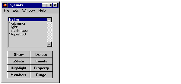
Controls
The scrollable list box displays all of the map layers currently associated with the map axes. An asterisk next to the layer name indicates that the layer is currently visible. An h next to the layer name indicates a layer that is plotted, but currently hidden.
The Plot button plots the selected map layer. Once the selected layer is plotted, the button toggles between Hide and Show, to turn the Visible property of the plotted objects to 'off' and 'on', respectively.
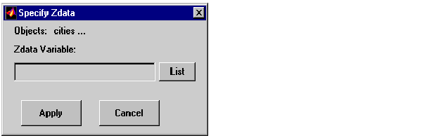
The Zdata button activates the Specify Zdata dialog box, which is used to enter the workspace variable containing the ZData for the selected map layer. Pressing the List button produces a list of all current workspace variables, from which the ZData variable can be selected. This entry can also be a scalar.
The Highlight button is used to toggle the selected map layer between highlighted and normal display.
The Members button brings up a list of members of the selected map layer. Members of a layer are defined by their Tag property.
The Delete button deletes the selected map layer from the map.
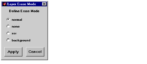
The Emode button activates the Layer Erase Mode dialog box, which is used to specify the erase mode of the selected map layer.
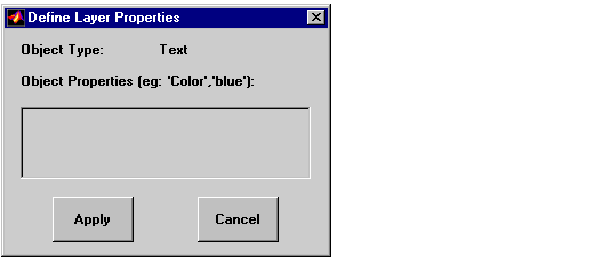
The Property button activates the Define Layer Properties dialog box, which is used to specify or change properties of all objects in the selected map layer. String entries must be enclosed in single quotes.
The Purge button deletes the selected map layer from the mlayers tool. Selecting Yes from the Confirm Purge dialog box deletes the map layer from both the mlayers tool and the map display. Selecting Data Only from the Confirm Purge dialog box deletes the map layer from the mlayers tool, while retaining the plotted object on the map display.
See Also
geographic data structure mobjects rootlayr
| | meshm | mobjects | |