| Mapping Toolbox | |
Coordinate Transformations
Previously, we discussed the concept of altering the display aspect of a map projection. One way to think of this is to consider redefining the coordinate system, and then displaying a projection based on the new system. For example, think about redefining your coordinate system so that your hometown is the origin. If you calculated a map projection in a normal aspect with respect to this transformed coordinate system, the resulting display would look like an oblique aspect with respect to the true coordinate system.
This transformation of coordinate systems can be useful independent of map displays. If a transformed coordinate system is selected so that your home town is the new north pole, then the transformed coordinates of all other points will provide interesting information.
The distance of each point from your hometown is then simply 90° minus the transformed latitude. For example, the point antipodal to your hometown would be the transformed south pole. -90°. Its distance from your hometown is then 90°-(-90°), or 180°, as expected. Points 90° distant from your hometown all have a transformed latitude of 0°. In fact, these points make up the transformed equator. The transformed longitudes correspond to the great circle azimuths of those points from your hometown.
When regular matrix maps are transformed in this manner, distance and azimuth calculations with the map variable reduce to row and column operations.
Vector Data - rotatem
As an example of transforming a coordinate system, suppose you live in Midland, Texas, at (32°N,102°W). You have a brother in Tulsa (36.2°N,96°W) and a sister in New Orleans (30°N,90°W).
What can we say about their homes, relative to yours?
dist2tuls = distance(midl_lat,midl_lon,tuls_lat,tuls_lon)
dist2tuls =
    6.5032
dist2newo = distance(midl_lat,midl_lon,newo_lat,newo_lon)
dist2newo =
    10.4727
Tulsa is about 6.5 degrees distant, New Orleans about 10.5 degrees distant. The great circle azimuths are the following:
az2tuls = azimuth(midl_lat,midl_lon,tuls_lat,tuls_lon)
az2tuls =
    48.1386
az2neworl = azimuth(midl_lat,midl_lon,newo_lat,newo_lon)
az2neworl =
    97.8644
The absolute difference in these azimuths is 49.7258°, a fact we will use later.
Today, you feel on top of the world, so make Midland, Texas, the north pole of a transformed coordinate system. To do this, first determine the origin required to put Midland at the pole:
The origin of the new coordinate system will be (58°N,78°E). Midland is now at a new latitude of 90°.
What are the new coordinates of Tulsa and New Orleans? To calculate these, use the rotatem command. Since it defaults to radians, be sure to include the units input 'degrees':
[tuls_lat1,tuls_lon1] = rotatem(tuls_lat,tuls_lon,...
                                origin,'forward','degrees')
tuls_lat1 =
    83.4968
tuls_lon1 =
    -48.1386

[newo_lat1,newo_lon1] = rotatem(newo_lat,newo_lon,...
                                origin,'forward','degrees')
newo_lat1 =
    79.5273
newo_lon1 =
    -97.8644
Now, test the new coordinate system for the advertised properties. The distance to Tulsa was 6.5032° distant. Its colatitude in the new coordinate system is 90°-83.4968°, or 6.5032°. Similarly, the new colatitude of New Orleans, 90°-79.5273°, is the distance 10.4727°.
Additionally, the absolute difference in the azimuths of the two cities from Midland was 49.7258°. The difference in their new longitudes is -48.1386° - (-97.8644°), which is also 49.7258°, as advertised.
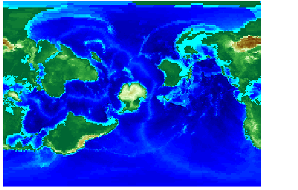
Matrix Data - neworig
A regular matrix map can be used to create a new general matrix map with its data rearranged to correspond to a new coordinate system. Suppose you want to transform the topo data to a new coordinate system in which Sri Lanka (7°N,80°E) is the North Pole.
An interesting feature of this new matrix map is that every cell in its first row is 0°-1° distant from the Sri Lankan point (7°N,80°E), and every cell in its second row is 1°-2° distant, etc. Another feature is that every cell in a particular column has the same great circle azimuth from the point.
| | The Origin Vector | Projection Computations | |