| Mapping Toolbox | |
EGM96 Geoid Model
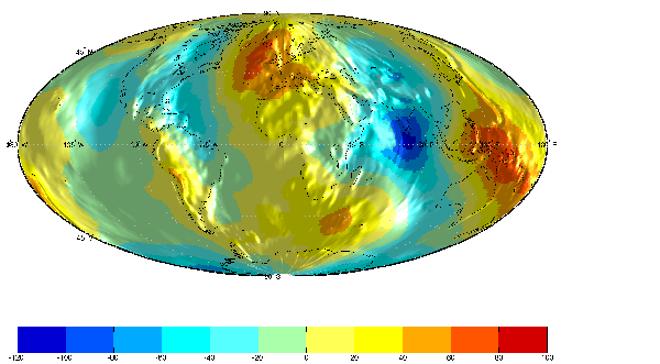
Much of the available matrix map data is elevations of the Earth's crust. For some applications it is important to know precisely the elevation and slope of sea level, or in the case of areas covered with land, where sea level would be. This surface of constant gravitational attraction is called the geoid, and improving man's understanding of it has been one of the primary concerns of the field of geodesy. Perhaps the best available global geoid model is EGM96, developed by NASA Goddard and NIMA. EGM 96 is a spherical harmonic model of the geoid complete to degree and order 360. The lower resolution atlas data in geoid.mat is derived from the EGM 96 grid.
The egm96geoid function reads the 'WW15MGH.GRD' file of geoid heights derived from the EGM 96 harmonic coefficients on a 15 minute grid. There are 721 rows and 1441 columns of values in the grid at full resolution. The grid is available from <http://www.nima.mil/GandG/wgs-84/egm96.html> as either a DOS self-extracting compressed file or a UNIX compressed file.
Read the EGM 96 geoid grid for the world, taking every fifth point. Display it as a lighted surface with colormap contours in a Hammer projection.
[map,maplegend] = egm96geoid(5);
worldmap('world','none');
setm(gca,'MapProjection','hammer'); tightmap
meshm(map,maplegend,size(map),map); plotm(coast,'k')
light; lighting phong; material(0.6*[ 1 1 1])
set(gca,'DataAspectRatio',[1 1 200]); gridm reset
zdatam(handlem('allline'),max(map(:)))
zdatam(handlem('alltext'),max(map(:)))
caxis([-120 100]); colormap(jet(11)); colorbar('horiz')
The high resolution grid is most useful for computing the geoid height at particular locations. If you plan to use a higher order interpolation method, be sure to get a matrix large enough to have several points about your locations.
Read a subset of the geoid grid at full resolution and interpolate to find the geoid height at a point between grid points.
[map,maplegend] = egm96geoid(1,[-10 -12],[129 132]);
z = ltln2val(map,maplegend,-11.1,130.22,'bicubic')
z =
    52.7151
| | Advanced Very High Resolution Radiometer (AVHRR) Global Change Data | U. S. Gridded Elevation Data | |