| Mapping Toolbox | |
U. S. Geological Survey 1:250,000 (100 meter) DEMs
The U. S. Geological Survey has released a series of Digital Elevation Maps in 1-degree quadrangles covering the contiguous United States, Hawaii, and limited portions of Alaska. The 1-degree DEMs are also referred to as 3-arc second or 1:250,000 scale DEM data. The horizontal resolution of this data is about 100 meters.
The data is derived from the U.S. Defense Mapping Agency's DTED-1 digital elevation model, which itself was derived from cartographic and photographic sources. The cartographic sources are maps from the 7.5 minute through 1-degree series (1:24,000 scale through 1:250,000 scale). There is no bathymetric data in this DEM.
Most of the 1-degree digital elevation models have grid spacings of 3 arc-seconds in both the latitude and longitude directions. Alaska has grid spacings of 6 arc-seconds for latitudes between 50 and 70 degrees North and 9 arc-seconds for latitudes greater than 70 degrees North.
The grid for the digital elevation maps is based on the World Geodetic System 1984 (WGS 84). Older DEMs were based on WGS 72. Elevations are in meters relative to the National Geodetic Vertical Datum of 1929 (NGVD 29) in the continental U.S. and local mean sea level in Hawaii.
The specified absolute horizontal accuracy of the DEM is 130 m, while the specified absolute vertical accuracy is ±30m. The relative horizontal and vertical accuracies are not specified but should be much better than the absolute accuracies.
The DEM data files can be retrieved over the Internet from the EROS Data Center's Web site located at <http://edcwww.cr.usgs.gov/> or their FTP server at <ftp://edcftp.cr.usgs.gov/>. The files are available sorted by state and file name or can be selected from an index map. Further information on the dataset is also available at the sites listed.
The data files are named according to towns or features within the quadrangle region. If you know the geographic limits of the area you want to map, you can look up the names on the USGS Web site or use the Mapping Toolbox usgsdems function, which returns a list of map quadrangle filenames covered by your region. Here are the names of the files covered by the Cape Cod maps used throughout this document:
usgsdems([41 44], [-72 -69])
ans =
    'providence-w'
    'providence-e'
    'chatham-w'
    'boston-w'
    'boston-e'
    'portland-w'
    'portland-e'
    'bath-w'
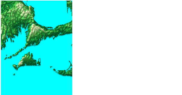
The Cape Cod region extends over several of the 1-degree quadrangles. Displaying the whole region at the full, 3 arc-second resolution would require enormous amounts of memory and time.
Display the region covered by the `providence-e' quadrangle using the usgsdem interface function and a downsampling factor of 5. The resulting map is a 241-by-241 element matrix. At full resolution, the map would be 1201-by-1201.
[map,maplegend] = usgsdem('providence-e',5);
map(map==0) = -1;
axesm mercator
meshm(map,maplegend,size(map),map); demcmap(map)
lightm(41.5,-70.5); material([.7 .7 1.5]); lighting gouraud
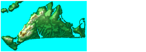
Zoom in further on Martha's Vineyards by providing appropriate latitude and longitude limits for the usgsdem function at full resolution. You can see some terracing effects in the data, an artifact of its derivation from topographic contour maps.
[map,maplegend] = usgsdem('providence-e',1,[41.2946 41.4829],...
                          [-70.8429 -70.4379]);
axesm mercator
meshm(map,maplegend,size(map),map); demcmap(map)
lightm(41.4,-70.65); material([.7 .7 1.5]); lighting gouraud
U.S. Geological Survey 1:24,000 (30m) DEMs
The highest resolution elevation data generally available is the USGS 1:24,000 scale DEMs. These maps have been generated from the contour lines on the paper 7.5 minute quadrangle map series. Data is available for much of the contiguous United States, Hawaii, and Puerto Rico. Because of the density of this data, little of it is available on-line. Some state agencies have collected and published files for smaller areas, such as the California Bay Area Regional Database at <http://bard.wr.usgs.gov/>. DEM files for other areas can be ordered from the USGS. These files have been released in several file formats. The USGS in the process of converting much of this data into the Spatial Data Transfer Standard. The usgs24kdem function reads data in the older standard format.
The data is stored as a series of profiles spaced 30 meters apart in a Universal Transverse Mercator grid. Unlike the 1:250,000 DEMs, adjacent quadrangles cannot be simply butted together to form a larger, gap-free map. There is no bathymetric data. The DEM files are ASCII files and can be transferred as text. Line ending conversion is not necessarily required.
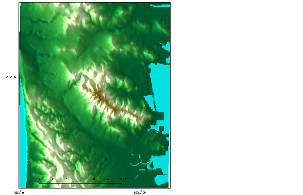
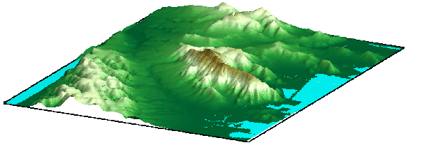
Read the 1:24,000 DEM for south San Francisco (sanfranciscos.dem), available from the Bay Area Regional Database at <http://bard.wr.usgs.gov/>. Read the entire file, taking every second point. The result is a 232-by-186 general matrix map. Because there are no negative elevations, move points at sea level down to color them blue.
[latgrat,longrat,map] = usgs24kdem('sanfranciscos.dem',2);
map(map==0) = -1;
latlim = [min(latgrat(:)) max(latgrat(:))];
lonlim = [min(longrat(:)) max(longrat(:))];
usamap(latlim,lonlim,'none')
surfm(latgrat,longrat,map,map-max(map(:)))
demcmap(map); daspectm('m',1); scaleruler
camlight(-80,0); lighting phong; material([.7 1 0])
| | EGM96 Geoid Model | Astronomical Data | |