| Mapping Toolbox | |
GTOPO30 and GLOBE
GTOPO30 and GLOBE are other sources of gridded land elevation data at a relatively high resolution. The datasets provide global coverage of land elevations at a horizontal resolution of 30 arc-second (about 1 kilometer or better). These datasets do not include bathymetry.
GTOPO30 was derived primarily from DTED0 and the Digital Chart of the World (DCW). GTOPO30 was developed by the Earth Resources Observation Systems (EROS) Data Center. Where no existing grid was available, elevations were computed using the Australian National University's ANUDEM computer program. This program combines elevation and drainage lines and points to interpolate elevations at the grid locations.
GLOBE, the Global Land One-km Base Elevation data, was compiled by the National Geophysical Data Center from more than 10 different sources of gridded elevation data. GLOBE may be considered a higher resolution sucessor to TerrainBase. The Mapping Toolbox reads data from GLOBE version 1.0.
GTOPO30 is accessible over the Internet and is available on CD-ROM. Ordering information, as well as the actual data files, can be found on-line. The data is available over the Internet via anonymous FTP from <ftp://edcftp.cr.usgs.gov/pub/data/gtopo30/global>. The data and some documentation are also available over the World Wide Web from <http://edcwww.cr.usgs.gov/landdaac/gtopo30/gtopo30.html> and <http://edcwww.cr.usgs.gov/landdaac/gtopo30/README.html>. The dataset consists of a total of 21,600 rows and 43,200 columns broken into 33 tiles, each generally covering 40-by-50 degrees. Each tile requires about 15 megabytes of storage when compressed, 80 megabytes uncompressed, and 160 megabytes to extract.
GLOBE is also available over the Internet and on CD-ROM. The data and some documentation are available over the World Wide Web from <http://www.ngdc.noaa.gov/seg/topo/globe.shtml>. The data is also available by anonymous ftp from <ftp://ftp.ngdc.noaa.gov/GLOBE_DEM/data/elev/>. The Web site also sells copies of the data on CD-ROM. The dataset is broken into 16 tiles, which take as much as 60 MB of storage. Uncompressed tiles take between 100 and 130 MB.
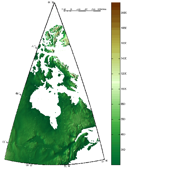
The Mapping Toolbox interface to GTOPO30 files is the gtopo30 function. It reads the elevations into regular matrix maps, optionally reducing and trimming data in the process. The following examples show the 'W100N90' tile, which covers the northeastern United States and eastern Canada. The files are available from the <http://edcwww.cr.usgs.gov/landdaac/gtopo30/gtopo30.html> Web page.
Read the entire elevation file, taking every twentieth point. Display the data as a lighted surface in a map axes prepared by worldmap. worldmap selects a polyconic projection for these map limits. Add a graphic scale and colorbar.
[map,maplegend] = gtopo30('W100N90',20);
[latlim,lonlim] = limitm(map,maplegend);
 worldmap(latlim,lonlim,'none')
meshm(map,maplegend,size(map),map);demcmap(map)
demcmap(map); daspectm('m',15)
camlight(-80,0); lighting phong; material([.5 5 0])
scaleruler('MajorTick',0:250:1000,'MinorTick',0:50:250,...
           'RulerStyle','patches')
colorbar
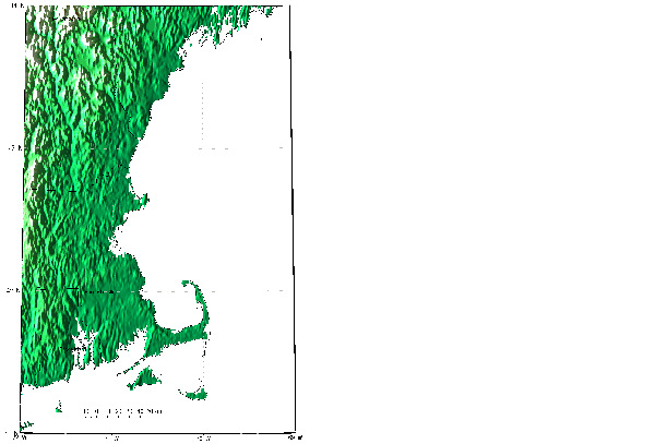
You can read a subset of the data by providing latitude and longitude limits. Here is the part of the dataset covering Cape Cod at the full resolution. The 30 arc-second GTOPO30 covers this region with a 360-by-360 matrix, which is 10 times finer than the 5 arc-minute (300 arc-second) ETOPO5 and TerrainBase data. This is also the same resolution as the data in the MATLAB cape workspace.
latlim = [41 44]; lonlim = [-72 -69];
[map,maplegend] = gtopo30('W100N90',1,latlim,lonlim);
figure
usamap(latlim,lonlim,'line')
zdatam('alltext',max(map(:)))
zdatam('allline',max(map(:)))
meshm(map,maplegend,size(map),map);demcmap(map)
demcmap(map); daspectm('m',15)
camlight(-80,0); lighting phong; material([.5 5 0])
scaleruler; colorbar
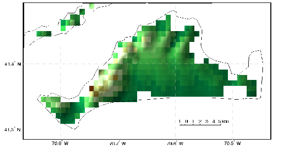
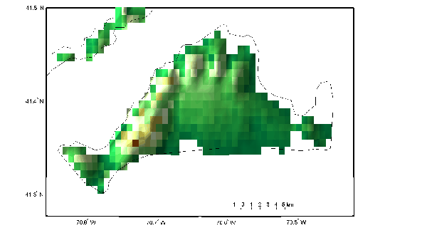
To see the ultimate resolution of the GTOPO30 data, extract only the area around Martha's Vineyard. Now you can see the individual pixels, and how the ocean areas are transparent. The ocean is coded as no data, and filled with NaNs.
You can determine which files contain data for a region using the gtopo30s command. Based on the latitude and longitude limits, gtopo30s determines which files you will need.
If your region requires more than one file, give gtopo30 the name of the directory containing the data. It will then read from each of the files and concatenate the data into a single matrix.
The GLOBE database is very similar to GTOPO30. It is also a tiled global land elevation database at 1 kilometer resolution. To read the GLOBE data, use the globedem command. This command should be distinguished from the three-dimensional globe projection. The globedem command works just like gtopo30, including the ability to concatenate data across tile boundaries. There is also a corresponding globedems command that lists the files required to cover an area.
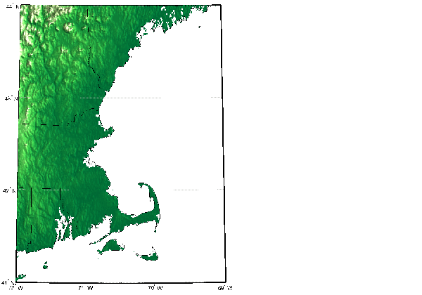
It may be difficult to distinguish the GLOBE data from GTOPO30 over large areas. Here is the corresponding GLOBE data for Cape Cod.
 globedems([41 44],[-72 -69])

ans =

    'f10g'

[map,maplegend] = globedem('f10g',1,[41 44],[-72 -69]);
worldmap(map,maplegend,'ldem3d')
h = displaym(usahi('stateline'));
set(h,'color','k'); zdatam('allline',max(map(:)))
Some differences can be seen at higher resolutions. Here is the GLOBE data for Martha's Vineyard. The shape of the coastline differs because of different clipping at the coastlines. Also, the highest elevation is slightly shifted, with GLOBE's version in a more likely location.
You can read both the GTOPO30 and GLOBE data with the demdataui graphical user interface described later in this chapter.
| | Global Bathymetry Predicted from Satellite Altimetry | Digital Terrain Elevation Data Model | |