| Mapping Toolbox | |
Digital Terrain Elevation Data Model
The Digital Terrain Elevation Data (DTED) Model is a series of gridded elevation models with global coverage at resolutions of 1 kilometer or finer. It is a product of the U. S. National Imagery and Mapping Agency (NIMA), formerly the Defense Mapping Agency (DMA). The data is provided as 1-by-1 degree tiles or elevations on geographic grids with product-dependent grid spacing.
The lowest resolution data is the DTED Level 0, with a grid spacing of 30 arc-seconds, or about 1 kilometer. This version of the data has been made available over the Internet at <http://www.nima.mil/geospatial/products/DTED/dted.html>. The intended coverage is global, but there are currently large gaps in coverage for South America and Africa. DTED Level 1 has a resolution of 3 arc-seconds, or about 100 meters, and was the primary source for the USGS 1:250,000 (1 degree) DEMs. DTED Level 2 and above are at even higher resolutions. DTED Level 1 and above are available to the U. S. Department of Defense and its contractors from NIMA.
The DTED files are binary. No line ending conversion or byte swapping is required. The files have filenames with the extension dtN, where N is the level of the DTED product.
Which files are needed to cover the Cape Cod area?
dteds([41.1 43.9],[-71.9 -69.1])

ans =

    '\DTED\W072\N41.dt0'
    '\DTED\W071\N41.dt0'
    '\DTED\W070\N41.dt0'
    '\DTED\W072\N42.dt0'
    '\DTED\W071\N42.dt0'
    '\DTED\W070\N42.dt0'
    '\DTED\W072\N43.dt0'
    '\DTED\W071\N43.dt0'
    '\DTED\W070\N43.dt0'
When your region extends across more that one tile, you can have the dted command concatenate the tiles into a single matrix. Just tell the dted command the location of the dted directory.
How many files are needed just around Martha's Vineyard?
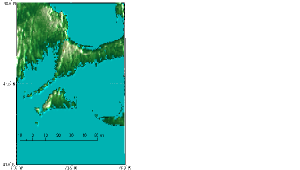
Retrieve the DTED0 data for Cape Cod from the Web page, and read the 1° tile at full resolution. The data is provided in a tar file named dn41w071.tar. The DTED0 elevation data file is in the w071 directory under the name n41.dt0. Read and display it as a lighted surface to show both large and small scale variations in the data. Because no bathymetric depths are provided, move elevations of zero down a bit to color them blue.
[map,maplegend] = dted('n41.dt0'); map(map==0)=-1;
[latlim,lonlim] = limitm(map,maplegend);

usamap(latlim,lonlim,'line')
meshm(map,maplegend,size(map),map); demcmap(map)
daspectm('m',40)
zdatam('allline',max(map(:)))
light; material([0.7 1 0.6]); lighting phong
scaleruler
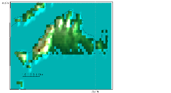
Read and display the data covering just Martha's Vineyard at the full resolution.
clmo surface
latlim = [41.2344 41.5053]; lonlim = [-70.8613 -70.4249];
setm(gca,'MapLatLimit',latlim,'MapLonLimit',lonlim); tightmap

[map,maplegend] = dted('n41.dt0',1,latlim,lonlim);
map(map==0)=-1;

meshm(map,maplegend,size(map),map); demcmap(map)
light; material([0.7 1 0.6]); lighting phong; daspectm('m',30)
scaleruler off; scaleruler
You can read the DTED data with the demdataui graphical user interface described below.
| | GTOPO30 and GLOBE | Reading Elevation Data Interactively | |