| Mapping Toolbox | |
Global Bathymetry Predicted from Satellite
Altimetry
High resolution bathymetric data has been lacking for much of the world because few ships made sounding measurements away from heavily used sea lanes. Recently declassified satellite altimetry revealed that the topography of the ocean floor is mirrored in undulations of the ocean surface. Sandwell and Smith have developed a bathymetric model that combines ship soundings and satellite altimetry to infer the topography of the ocean floor. Land data is taken from the GTOPO30 elevation data, described below. The global topography is stored in a Mercator projection at a nominal resolution of 2 arc-seconds (or about 4 kilometers), covering the globe to 72 degrees north and south.
The data is available over the Internet via anonymous FTP from
<ftp://topex.ucsd.edu/pub/global_topo_2min/>.
Download the latest version of file topo_x.2.img, where x is the version number, and rename it topo_6.w.img for compatibility with the satbath function. This function reads the binary files as they are, i.e., you should not use byte swapping software on these files. Some documentation is also available over the World Wide Web at
<http://topex.ucsd.edu/marine_topo/mar_topo.html>
<http://www.ngdc.noaa.gov/mgg/announcements/announce_predict.html>
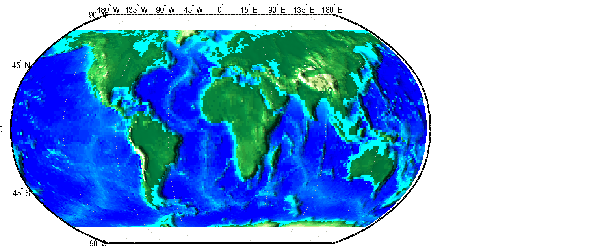
The satbath function reads the data into a general matrix map that can be displayed in any projection. Here is the entire file reduced by a factor of 50. You can see the latitude limits in the data.
[latgrat,longrat,map] = satbath;
worldmap('world','none'); setm(gca,'MLabelParallel','n')
surfm(latgrat,longrat,map,map)
demcmap(map); daspectm('m',30)
camlight(-80,0); lighting phong; material([.3 5 0])
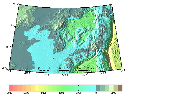
The richness of the data is evident in a map at close to the full resolution. You can bring out the small features of the data with a lightened hsv colormap for ocean depths, and a lighter version of the standard land colormap. This colormap is similar to one used in posters of this data by Sandwell and Smith.
latlim = [30 45]; lonlim = [115 145];
[latgrat,longrat,map] = satbath(2,latlim,lonlim);
worldmap(latlim,lonlim,'none')
surfm(latgrat,longrat,map,map)
landcmap = hsv2rgb([0.5 0.3 0.6; 0.25 0.2 1; 0.07 0.4 0.6]);
seacmap = [  1   0.5   0.5
             1   1     0.5
           0.5   1     0.5
           0.5   1     1  ];
demcmap('inc',map,500,seacmap,landcmap); daspectm('m',5)
material([0.4 3 0]); camlight(-80,0); lighting phong
scaleruler('MajorTick',0:250:1000,'MinorTick',0:50:250,...
           'RulerStyle','patches')
colorbar('horiz')
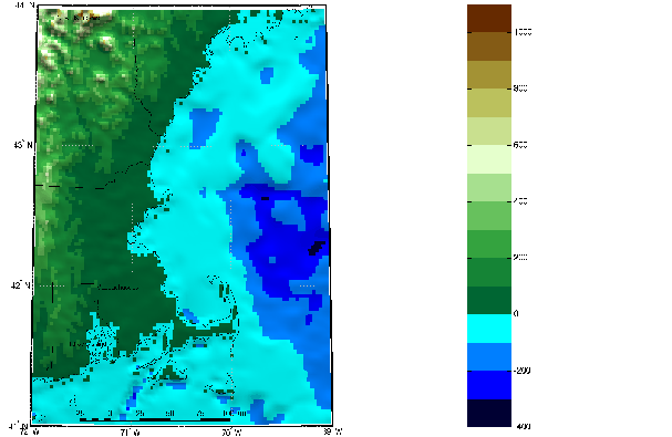
The data at the limit of resolution can be seen in this map of Cape Cod. The position of the land-sea interface is off in some places. This may be because the dataset uses odd or even numbers to indicate the source of the data.
latlim = [41 44]; lonlim = [-72 -69];
[latgrat,longrat,map] = satbath(1,latlim,lonlim);

usamap(latlim,lonlim,'line')
zdatam('alltext',1100); zdatam('allline',1100)
surfm(latgrat,longrat,map,map)
demcmap('inc',map,100); daspectm('m',5)
material([0.4 3 0]); camlight(0,80); lighting phong
scaleruler('MajorTick',0:25:100,'MinorTick',0:5:25,...
           'RulerStyle','patches')
colorbar
You can also read this data with the demdataui graphical user interface described later in this chapter.
| | ETOPO5 and TerrainBase | GTOPO30 and GLOBE | |