| Mapping Toolbox | |
ETOPO5 and TerrainBase
ETOPO5 and TerrainBase are digital elevation models with worldwide coverage at a resolution of 5 minutes (10 kilometers or better). They are both compilations of data from a variety of different sources, including the U.S. Naval Oceanographic Office, U.S. Defense Mapping Agency, U.S. Navy Fleet Numerical Oceanographic Center, Bureau of Mineral Resources in Australia, and the Department of Industrial and Scientific Research in New Zealand. The ETOPO5 dataset was assembled by Margo Edwards at Washington University, in St. Louis, Missouri.
An overview of this dataset can be found at several Internet locations, including the U.S. Geological Survey Web site located at <http://edcwww.cr.usgs.gov/> and the U.S. National Geophysical Data Center home page at <http://www.ngdc.noaa.gov/>.
The ETOPO5 data is read using the etopo5 external interface function for the version of the database contained in the two text files, `etopo5.southern.bat' and `etopo5.northern.bat.' These files occupy about 60 megabytes of total disk space when uncompressed and are provided via FTP by The MathWorks, Inc. at <ftp://ftp.mathworks.com/pub/mathworks/toolbox/map/extMapData/>. You can also read the much more compact binary file version `new_etopo5.bil' available from <http://www/geo.cornell.edu/geology/seber/datasets/new_etopo5.bil>.
ETOPO5 has been superseded by TerrainBase, which is similar in coverage to ETOPO5, but corrects many of its flaws, including discontinuities at joins between datasets, systematic shifts in location, and lack of data in some regions. TerrainBase is a compilation of the best available, public domain data from almost 20 different sources.
The TerrainBase dataset was created by the National Geophysical Data Center and World Data Center-A for Solid Earth Geophysics in Boulder, Colorado. The model is currently under development and will be updated as new data sources become available. Further information on the TerrainBase DEM can be found at the U.S. National Geophysical Data Center home page at <http://www.ngdc.noaa.gov/>.
TerrainBase data is read using the tbase function. The data files are available on CD-ROM and via Internet. NOAA/NGDC provides ordering information and downloadable files at their Web site. The files require about 18 megabytes of disk space when uncompressed.
You should use the TerrainBase dataset unless you have a good reason to want ETOPO5. TerrainBase corrects some errors, takes up less space, and can be read faster than ETOPO5. The following examples will read TerrainBase data, but you can substitute ETOPO5 data by simply using the etopo5 function instead of tbase.
A 10 kilometer resolution DEM has so much data that it is usually impractical to read the entire file into memory. The full matrix has 2160 by 4320 elements. Both the etopo5 and tbase functions allow you to reduce the resolution by discarding data points.
Read every twelfth point in the global data base.
[map,maplegend] = tbase(12);
whos
|
|
|
|
|
|
|
|
|
180x360 |
518400 |
|
|
1x3 |
24 |
|
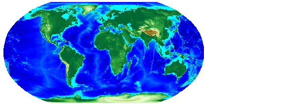
Plot the map on a Robinson projection:
This is a regular matrix map at the same resolution as the topo map. It differs from topo in that the values represent nearest neighbor samples, rather than averages over the matrix cell, resulting in a rougher appearance.
Elevations and depths are given in meters above or below mean sea level. Some parts of the world are represented by data with a horizontal resolution as coarse as 1 degree by 1 degree. The vertical resolution varies from 1 meter for Australia and New Zealand to as much as 150 meters for parts of Africa, Asia, and South America. Oceanographic data in areas shallower that 200 meters contains little detail because of the way depth contours were converted to gridded depths.
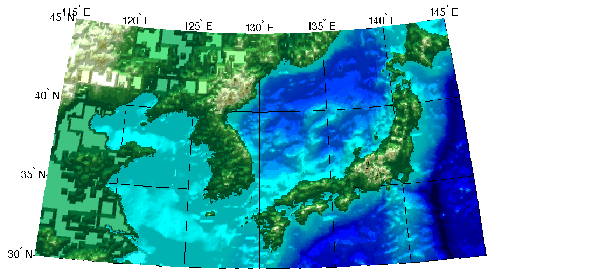
The areas with 1 degree horizontal data can be clearly seen when you display data for a small region at the full resolution of the database.
Display the Korean peninsula and Japan:
[map,maplegend] = tbase(1,[30 45],[115 145]);
axesm('MapProjection','polycon',...
      'MapLatLimit',[30 45],'MapLonLimit',[115 145],...
      'MLabelLocation',5,'MLineLocation',5,...
      'PLabelLocation',5,'PLineLocation',5,...
      'GLineStyle','-','GAltitude',inf) ;
gridm; mlabel; plabel
meshm(map,maplegend,size(map),map); demcmap(map);
lightm(37.5,130); material([.7 .7 1.5]); lighting gouraud
Note the discontinuities in some areas, particularly the regions in China.
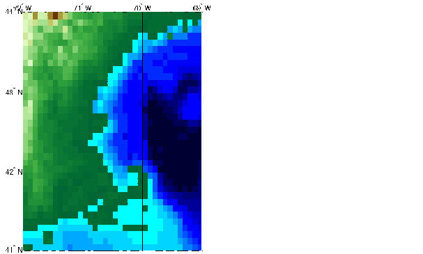
You can get a sense for the resolution of this dataset by comparing a TerrainBase map of the Cape Cod region in the Northeastern United States with maps of the same region using other datasets. TerrainBase and ETOPO5 have a horizontal resolution of 12 cells per degree, so the Cape Cod map consists of 36 by 36 cells.
[map,maplegend] = tbase(1,[41 44],[-72 -69]);
whos
|
|
|
|
|
|
|
|
|
36x36 |
10368 |
|
|
1x3 |
24 |
|
You can also read this data with the demdataui graphical user interface described later in this chapter.
| | Global Matrix Data | Global Bathymetry Predicted from Satellite Altimetry | |