| Mapping Toolbox | |
Create and assign a colormap to a digital elevation matrix map
Activation
| Command Line |
Maptool |
| demcmap |
Colormaps Digital Elevation Digital Elevation |
Description
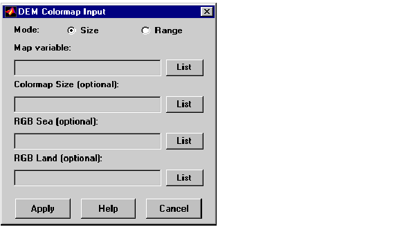
demcmap activates the DEM Color Map Input dialog box, which accepts inputs used to create a colormap for a digital elevation matrix map, and then applies the colormap to the current figure. The number of land and sea colors in the colormap is appropriate for the maximum elevations and depths of the matrix map.
Controls
The Mode selection buttons are used to specify whether the length of the colormap is specified or whether the altitude range increment assigned to each color is specified.
The Map variable edit box is used to specify the matrix map containing the elevation data.
The Color Map Size edit box is used in Size mode. This entry defines the length of the colormap. If omitted, a default length of 64 is used. This entry must be a scalar value.
The Altitude Range edit box is used in Range mode. This entry defines the altitude range increment assigned to each color. If omitted, a default increment of 100 is used. This entry must be a scalar value.
The RGB Sea edit box is used to define colors for data with negative values. The actual sea colors of the generated colormap are interpolated from this matrix. This entry can be a matrix of any length (n by 3). The colormap matrix of the current figure can be used by entering the string 'window' in this box. The demcmap function provides default sea colors, which are used if this entry is left blank.
The RGB Land edit box is used to define colors for data with positive values. The actual land colors of the generated colormap are interpolated from this matrix. This entry can be a matrix of any length (n by 3). The colormap matrix of the current figure can be used by entering the string 'window' in this box. The demcmap function provides default sea colors, which are used if this entry is left blank.
Pressing the Apply button accepts the input data, creates the colormap, and assigns it to the current figure.
Pressing the Cancel button disregards any input data and closes the DEM Color Map Input dialog box.
See Also
demcmap
| | contourm, contour3m | fillm, fill3m, patchm, patchesm | |