| Mapping Toolbox | |
Project 2-D and 3-D contour plots onto the current map axes
Activation
| Command Line |
Maptool |
| contourm contour3m |
Map Contours Contours |
Description
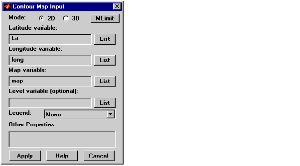
contourm and contour3m activate a Contour Map Input dialog box to project contour lines onto the current map axes.
If no map axes are current, a No Map Axes dialog box appears. Choose Yes to activate the Projection Control dialog box for defining map axes properties. Upon creation of the map axes, the Contour Map Input dialog box appears.
Controls
The Mode selection buttons are used to indicate a two- or three-dimensional contour plot.
The MLimit button brings up a Map Limit Input dialog box that computes the limits of a regular matrix map and stores them as variables that can be used as the latitude and longitude inputs for the contour plot. This enables the creation of contour plots for regular matrix maps. See limitm in this guide for more information about the Map Limit Input dialog box.
The Latitude variable edit box is used to specify the workspace variable containing the latitude vector or matrix for the contour plot. If a vector, it should be monotonically increasing and describe the latitude of each row of the matrix map. If a matrix, it should be the size of the map matrix and give the latitude associated with each map matrix element.
The Longitude variable edit box is used to specify the workspace variable containing the longitude vector or matrix for the contour plot. If a vector, it should be monotonically increasing and describe the longitude of each column of the matrix map. If a matrix, it should be the size of the map matrix and give the longitude associated with each map matrix element.
The Map variable edit box is used to specify the workspace variable containing the matrix map.
The Level variable edit box is used to specify the workspace variable containing the values of the contours to be plotted. A vector of contour level values, enclosed in brackets, can be entered instead of a variable name. If omitted, the contour values are chosen automatically.
Pressing the List button produces a list of all current workspace variables, from which the latitude, longitude, map, and level variables can be selected.
The Legend pull-down menu is used to select the type of contour labeling or legend to be added to the plot. If the Plot Legend option is selected, any existing legend is deleted.
The Other Properties edit box is used to specify additional properties of the contour lines, such as 'Color','b'. String entries must be enclosed in quotes. Linespec strings, such as 'c-', are also valid entries.
Pressing the Apply button accepts the input data and projects the contour plot onto the current map axes.
Pressing the Cancel button disregards any input data and closes the Contour Map Input dialog box.
| | cometm, comet3m | demcmap | |