| Mapping Toolbox | |
High-Resolution World Atlas Data
The worldhi global atlas data contains a set of very large-scale (approximately 1:1,000,000) data for use in regional displays. The data is provided in the form of Mapping Toolbox geographic data structures containing national boundaries, ocean names, and some cities.
You can request the outline of a particular country by providing the name. For a complete list of names, type worldhi with no arguments.
worldhi

WORLDLO atlas data:


  Geographic Data Structures:

    POpatch       - Countries as patches
    POtext        - Names of water bodies as text
    PPpoint       - Major cities as points
    PPtext        - Major cities as text labels

  Countries in the WORLDHI database:

    Afghanistan
    Agalega Island (MAU)
    Albania
    Alderney (UK)
    Algeria
    American Samoa (USA)
    Andorra
...
When you provide a country name, worldhi returns a geographic data structure containing the NaN-clipped vectors with the outline of the mainland and islands. The result also contains some additional fields over those required by the definition of the Geographic Data Structure. The latlim and lonlim fields contain the limits of a bounding box for the country in its entirety. The area field contains the area (in units of square kilometers) and the latitude and longitude limits the bounding box for each of the mainland and islands.
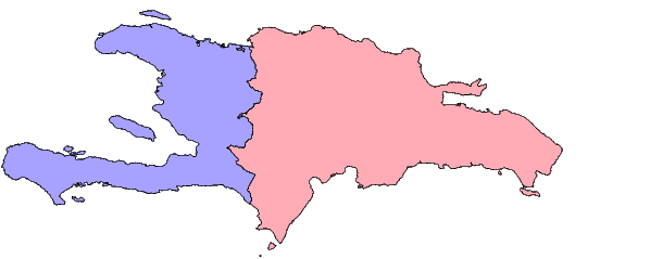
worldhi('Haiti')

ans =

             type: 'patch'
    otherproperty: {}
         altitude: []
              lat: [2011x1 double]
             long: [2011x1 double]
              tag: 'Haiti'
           latlim: [18.021 20.088]
          longlim: [-74.479 -71.613]
             area: [5x1 double]
          latlims: [5x2 double]
         longlims: [5x2 double]
            sname: 'Haiti'
You can request more than one country at a time by providing a string matrix or a cell array of strings.
worldhi({'Haiti','Dominican Republic'})

ans =

1x2 struct array with fields:
    type
    otherproperty
    altitude
    lat
    long
    tag
    latlim
    longlim
    area
    latlims
    longlims
    sname
The geographic data structures can be displayed on a map axes with displaym, or extracted to vectors of latitude and longitude with extractm.
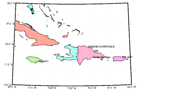
You can also have worldhi return all country outlines present within a geographic quadrangle. Here are the outlines for parts of countries that fall within the requested latitude and longitude limits. Note that worldhi will omit islands or the mainland of a country with bounding boxes that fall outside of the requested limits.
latlim = [15 25]; lonlim = [-80 -65];
s = worldhi(latlim,lonlim);
strvcat(s.tag)

ans =

Bahamas, The
Cayman Islands (UK)
Cuba
Dominican Republic
Haiti
Jamaica
Navassa Island (USA)
Puerto Rico (USA)
Turks and Caicas Islands (UK)
Virgin Islands, U.S. (USA)
While you can build up your own map displays using low level commands like axesm and displaym, the easy way to make a base map from this data is with the worldmap command. The worldhi command takes care cartographic details like selecting a projection, setting standard parallels, and grid and label increments. Here is a base map for the same area.
The optional arguments to worldhi can be used to omit islands smaller than some threshold, or to control how names are matched. You may have noticed the political affiliations in the names of some of the islands in the previous example. Here is an example that extracts all of entries in the worldhi database showing affiliation with the United Kingdom.
s = worldhi('(UK)','findstr');
strvcat(s.tag)

ans =

Alderney (UK)
Bermuda (UK)
British Indian Ocean Territory (UK)
Cayman Islands (UK)
Falkland Islands [Islas Malvinas] (UK)
Gibraltar (UK)
Gough Island (UK)
Guernsey (UK)
Jersey (UK)
Montserrat (UK)
Pitcairn Islands (UK)
Saint Helena (UK)
South Georgia and the South Sandwich Islands (UK)
Tristan da Cunha Group (UK)
Turks and Caicas Islands (UK)
United Kingdom (UK)
Virgin Islands, British (UK)
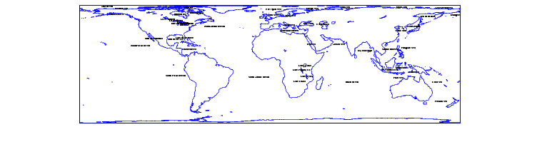
In addition to the country outline, the worldhi database also contains some information that complements the worldlo data. The POtext structure contains a list of ocean names that can be used to annotate map displays.
axesm lambcyln
plotm(coast)
tightmap
displaym(worldhi('POtext'))
set(handlem('alltext'),'fontsize',6)
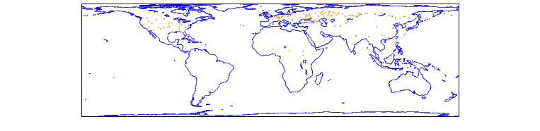
The worldhi database also includes a set of city location markers and text labels. The worldhi populated place structures contain cities not in worldlo's similar PPpoint and PPtext structures. Here the city markers in the worldhi data are shown in red, while the cities in worldlo are orange.
clmo all
h = displaym(worldhi('PPpoint'));
set(h,'color','r')
displaym(worldlo('PPpoint'))
plotm(coast)
| | Low-Resolution World Atlas Data | World Matrix Data | |