| Mapping Toolbox | |
Political
The Mapping Toolbox also provides a set of political matrix data for the continental United States located in the usamtx MAT-file.
load usamtx
whos
|
|
|
|
|
|
|
|
clrmap |
54x3 |
1296 |
|
map |
140x370 |
414400 |
|
maplegend |
1x3 |
24 |
|
states |
54x15 |
1620 |
|
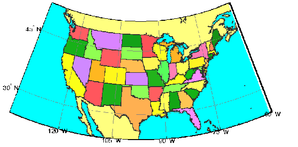
The data is in a regular matrix map format, similar to that discussed in the World Matrix Data section. The variable map is at a resolution of 5 cells per degree, or roughly 20 kilometers or better. Recall that the resolution of the worldmtx data is 1 cell per degree; hence, this dataset is five times finer. A colormap has been provided, along with a vector of state names, both corresponding to the political code, or index, used in the map matrix.
Display the matrix map in an Albers Equal-Area Conic projection:
axesm('MapProjection','eqaconic','MapParallels',[],...
    'MapLatLimit',[24 52],'MapLonLimit',[-134 -60],...
    'MLabelLocation',15,'MLineLocation',15,...
    'PLabelLocation',15,'PLineLocation',15,...
    'GColor',.5*[1 1 1],'GLinestyle','-',...
    'MLabelParallel','south')
framem; gridm; mlabel; plabel
meshm(map,maplegend); colormap(clrmap)
As with the world matrix data, the low resolution of this data makes it suitable for only large area displays. Vector maps are more appropriate where more detail is required. GUI Tools describes how to create higher resolution matrix maps from vector maps.
The primary use of this dataset is to determine which state contains a particular geographic point. In what state is Alamogordo (32.8990° N and 105.9570° W)?
You can create your own higher resolution political matrix maps using vec2mtx.
| | Medium Resolution State Outlines | Terrain | |