| Mapping Toolbox | |
Medium Resolution State Outlines
Another more detailed set of state outlines is available in the Mapping Toolbox. The data in the usahi MAT-file is similar in format to the state structure found in usalo but contains more detailed coastlines and islands. The resolution of stateline in the usahi workspace is about three times greater than the corresponding state in the usalo workspace.
load usahi
whos
|
|
|
|
|
|
|
|
|
|
statelin |
1x51 |
837656 |
|
|
statepatch |
1x51 |
837758 |
|
|
statetext |
1x51 |
51190 |
|
|
The listed variables are all formatted geographic data structures containing lines, patches, or text. The data in the stateline structure is the same as that in statepatch but has been defined to display as lines rather than patches. The structure statetext contains the corresponding names of the states. Note that because of the higher resolution of this data, it may require more than the default memory size to display and will take longer to project and render. This difference is particularly marked for patches.
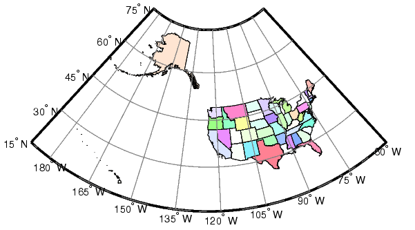
Display the map in an Equal-Area Conic projection:
axesm('MapProjection','eqaconic','mapparallels',[],...
    'MapLatLimit',[15 75],'MapLonLimit',[-188 -60],...
    'MLabelLocation',15,'MLineLocation',15,...
    'PLabelLocation',15,'PLineLocation',15,...
    'GColor',.5*[1 1 1],'GLineStyle','-',...
    'MLabelParallel','south')
framem; gridm; mlabel; plabel
displaym(statepatch); polcmap
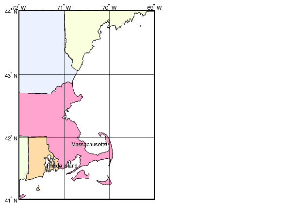
At this scale, it is difficult to see the difference between this data and the much smaller usalo workspace. By focusing on the Cape Cod region, the higher resolution becomes more apparent:
figure
axesm('MapProjection','mercator','Frame','on',...
    'MapLatLimit',[41 44],'MapLonLimit',[-72 -69])
gridm('MLineLocation',1,'PLineLocation',1,'GLineStyle','-')
mlabel('MLabelLocation',1)
plabel('PLabelLocation',1)
displaym(statepatch)
h = displaym(statetext); trimcart(h)
polcmap
Here is the zoomed-in region of Cape Cod. The level of detail is noticeably greater than that for the data in the usalo MAT-file.
You can use usamap to quickly create base maps with this data. Just provide the state name or geographic limits. This function will handle the cartographic details like selecting a projection, setting the map limits, and setting the origin and the grid and label spacings. You can also use the usahi interface function to load one of the atlas data structures as an argument to a function, or load just that structure into the workspace.
| | United States Vector Data | United States Matrix Data | |