| Mapping Toolbox | |
Track Laydown - Displaying Navigational Tracks
Navigational tracks are most useful when graphically displayed. Traditionally, the navigator identifies and plots waypoints on a Mercator projection and then connects them with a straightedge, which on this projection results in rhumb line tracks. In the previous example, waypoints were chosen to approximate a great circle route, but they may be selected for a variety of other reasons.
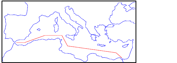
Let's say that after arriving at Cape St. Vincent, your tanker must traverse the Straits of Gibraltar and then travel on to Port Said, the northern terminus of the Suez Canal. On the scale of the Mediterranean Sea, following great circle paths is of little concern compared to ensuring that the many straits and passages are safely transited. The navigator selects appropriate waypoints and plots them.
To do this with the Mapping Toolbox, you can display a map axes with a Mercator projection, select appropriate map latitude and longitude limits to isolate the area of interest, plot coastline data, and interactively mouse-select the waypoints with the inputm command. The track command will generate points to connect these waypoints, which can then be displayed with plotm.
For illustration, assume that the waypoints are known (or were gathered using inputm). To learn about using inputm, see Interacting with Displayed Maps, or the online Mapping Toolbox reference documentation.
waypoints = [36 -5; 36 -2; 38 5; 38 11; 35 13; 33 30; 31.5 32]
waypoints =
    36.0000   -5.0000
    36.0000   -2.0000
    38.0000    5.0000
    38.0000   11.0000
    35.0000   13.0000
    33.0000   30.0000
    31.5000   32.0000
load coast
axesm('MapProjection','mercator',...
'MapLatLimit',[30 47],'MapLonLimit',[-10 37])
framem
plotm(lat,long)

[lttrk,lntrk] = track(waypoints);
plotm(lttrk,lntrk,'r')
Although these track segments are straight lines on the Mercator projection, they will be curves on others:
The segments of a track like this are called legs. Each of these legs can be described in terms of course and distance. The function legs will take the waypoints in navigational track format and return the courses and distances required for each leg. Remember, the order of the points in this format determines the direction of travel. Courses are therefore calculated from each waypoint to its successor, not vice-versa.
[courses,distances] = legs(waypoints)
courses =
    90.0000
    70.3132
    90.0000
    151.8186
    98.0776
    131.5684
distances =
    145.6231
    356.2117
    283.6839
    204.2073
    854.0092
    135.6415
Since this is a navigation function, the courses are all in degrees and the distances are in nautical miles. From these distances, speeds required to arrive at Port Said at a given time can be calculated. Southbound traffic is allowed to enter the canal only once per day, so this information might be economically significant, since unnecessarily high speeds can lead to high fuel costs.
| | Planning | Dead Reckoning | |