| Mapping Toolbox | |
Dead Reckoning
When sailors first ventured out of sight of land, they faced a daunting dilemma. How could they find their way home if they didn't know where they were? The practice of dead reckoning is an attempt to deal with this problem. The term is derived from deduced reckoning.
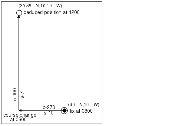
Briefly, dead reckoning is vector addition plotted on a chart. For example, if you had a fix at (30°N,10°W) at 0800, and you proceeded due west for 1 hour at 10 knots, and then you turned north and sailed for 3 hours at 7 knots, you should be at (30.35°N,10.19°W) at 1200. All's well, ring eight bells on time, Mr. Bowditch, right?
However, Mr. Bowditch shoots the sun at local apparent noon and discovers that the ship's latitude is actually 30.29°N. What's worse, he lives before the invention of a reliable chronometer, and so he cannot calculate his longitude at all from this sighting. What happened?
Leaving aside the difficulties in speed determination and the need to tack off course, even modern craft have to contend with winds and currents. However, despite these limitations, dead reckoning is still used for determining position between fixes and for forecasting future positions. This is because dead reckoning provides a certainty of assumptions that estimations of wind and current drift cannot.
When navigators establish a fix from some source, be it from piloting, celestial, or satellite observations, they plot a dead reckoning (DR) track, which is a plot of the intended positions of the ship forward in time. In practice, dead reckoning is usually plotted for 3 hours in advance, or for the time period covered by the next three expected fixes. In open ocean conditions, hourly fixes are sufficient; in coastal pilotage, three-minute fixes are common.
Specific DR positions, which are sometimes called DRs, are plotted according to the Rules of DR:
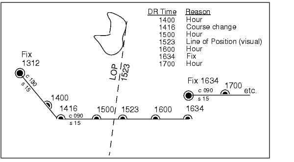
For example, the navigator plots these DRs:
Notice that the 1523 DR does not coincide with the LOP at 1523. Although note is taken of this variance, one line is insufficient to calculate a new fix.
The Mapping Toolbox includes the function dreckon, which calculates the DR positions for a given set of courses and speeds. The function provides DR positions for the first three rules of dead reckoning. The approach is to provide a set of waypoints in navigational track format corresponding to the plan of intended movement.
The time of the initial waypoint, or fix, is also needed, as well as the speeds to be employed along each leg. Alternatively, a set of speeds and the times for which each speed will apply can be provided. dreckon will return the positions and times required of these DRs:
dreckon calculates the times for positions of each course change, which will occur at the waypoints
dreckon calculates the positions for each whole hour
dreckon calculates positions for these times, if they do not occur at course changes
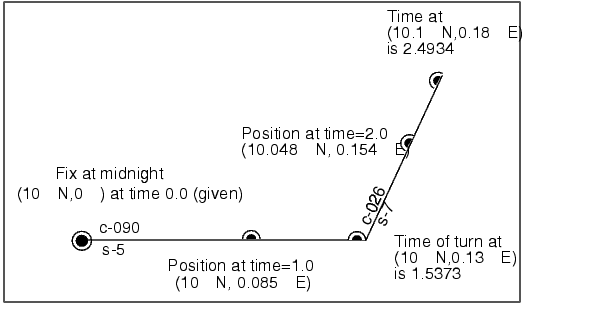
Imagine you have a fix at midnight at the point (10°N,0°):
You intend to travel east and alter course at the point (10°N,0.13°E) and head for the point (10.1°N,0.18°E). On the first leg, you will travel at 5 knots, and on the second leg you will speed up to 7 knots.
To determine the DR points and times for this plan, use dreckon:
[drlat,drlon,drtime] = dreckon(waypoints,fixtime,speeds);
[drlat drlon drtime]
ans =
    10.0000    0.0846    1.0000     % Position at 1 am
    10.0000    0.1301    1.5373     % Time of course change
    10.0484    0.1543    2.0000     % Position at 2 am
    10.1001    0.1801    2.4934     % Time at final waypoint
Here is an illustration of this track and its DR points:
However, you would like to get to the final point a little earlier to make a rendezvous. You decide to recalculate your DRs based on speeding up to 7 knots a little earlier than planned. The first calculation tells you that you were going to increase speed at the turn, which would occur at a time 1.5373 hours after midnight, or 1:32 a.m. (at time 0132 in navigational time format). What time would you reach the rendezvous if you increased your speed to 7 knots at 1:15 a.m. (0115, or 1.25 hours after midnight)?
To indicate times for speed changes, another input is required, providing a time interval after the fix time at which each ordered speed is to end. The first speed, 5 knots, is to end 1.25 hours after midnight. Since you don't know when the rendezvous will be made under these circumstances, set the time for the second speed, 7 knots, to end at infinity. No DRs will be returned past the last waypoint.
spdtimes = [1.25; inf];
[drlat,drlon,drtime] = dreckon(waypoints,fixtime,...
                               speeds,spdtimes);
[drlat,drlon,drtime]
ans =
    10.0000    0.0846    1.0000   % Position at 1 am
    10.0000    0.1058    1.2500   % Position at speed change
    10.0000    0.1301    1.4552   % Time of course change
    10.0570    0.1586    2.0000   % Position at 2 am
    10.1001    0.1801    2.4113   % Time at final waypoint
This following illustration shows the difference:
The times at planned positions after the speed change are a little earlier; the position at the known time (2 a.m.) is a little farther along. With this plan, you will arrive at the rendezvous about 4 1/2 minutes earlier, so you may want to consider a more authoritative speed change.
| | Track Laydown - Displaying Navigational Tracks | Drift Correction | |