| Mapping Toolbox | |
Planning
We know that the shortest path between two geographic points is a great circle. Sailors and aviators are interested in minimizing distance travelled, and hence delay. We also know that the rhumb line is a path of constant heading, the natural means of travelling. In general, to follow a great circle path, one would have to continuously alter course. This is impractical. However, a great circle path can be approximated by rhumb line segments so that the added distance is minor and the number of course changes minimal.
Surprisingly, very few rhumb line track legs are required to closely approximate the distance of the great circle path.
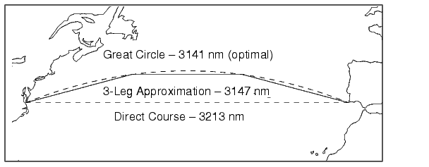
Consider the voyage from Norfolk, Virginia (37°N,76°W), to Cape St. Vincent, Portugal (37°N,9°W), one of the most heavily trafficked routes in the Atlantic. A due-east rhumb line track is 3,213 nautical miles in length, while the optimal great circle distance is 3,141 nautical miles.
Although the rhumb line path is only a little more than 2% longer, this is an additional 72 miles over the course of the trip. For a 12-knot tanker, this results in a 6-hour delay, and in shipping, time is money. If just three rhumb line segments are used to approximate the great circle, the total distance of the trip is 3,147 nautical miles. Our tanker would suffer only a half-hour delay over optimal.
The Mapping Toolbox provides the function gcwaypts to quickly calculate waypoints in navigation track format in order to approximate a great circle with rhumb line segments. The syntax is simple:
All of the inputs for this command are scalars. The numlegs input is the number of equal length legs desired, which is 10 by default. The outputs are column vectors representing waypoints in navigational track format. The size of each of these vectors will be [(numlegs+1) 1]. Here are the points for the example illustrated above:
[latpts,lonpts] = gcwaypts(37,-76,37,-9,3)
latpts =
    37.0000
    41.5076
    41.5076
37.0000
lonpts =
    -76.0000
    -54.1777
    -30.8223
    -9.0000
These points represent waypoints along the great circle between which the approximating path follows rhumb lines. Four points are needed for three legs, because the final point at Cape St. Vincent must be included.
| | Fixing Position | Track Laydown - Displaying Navigational Tracks | |