| Mapping Toolbox | |
Transform azimuths from a projection space angle
Syntax
Background
While vectors along the y-axis always point to north in a cylindrical projection in the normal aspect, they may point east or west of north on conics, azimuthals, and other projections. This function computes the geographic azimuth for angles in the projected space
Description
az = vinvtran(x,y,th) transforms an angle in the projection space at the point specified by x and y into an azimuth angle in Greenwich coordinates. The map projection currently displayed is used to define the projection space. The input angles must be in the same units as specified by the current map projection. The inputs can be scalars or matrices of the equal size. The angle in the projection space angle th is defined positive counter-clockwise from the x axis.
az = vinvtran(mstruct,x,y,th) uses the map projection defined by the input struct to compute the map projection.
[az,len] = vfwdtran(...) also returns the vector length in the Greenwich coordinate system. A value of 1 indicates no scale distortion for that angle.
Examples
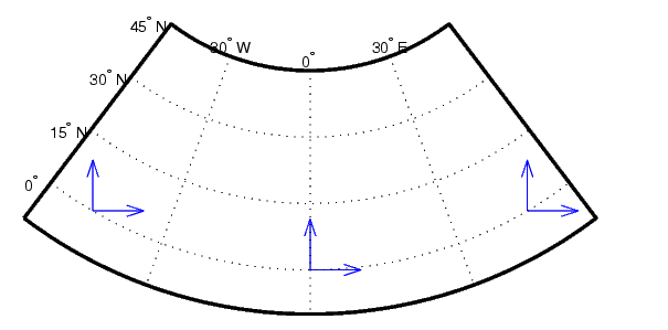
axesm('eqdconic','maplatlim',[-10 45],'maplonlim',[-55 55])
gridm; framem; mlabel; plabel

[x,y] = mfwdtran([0 0 0],[-45 0 45]);
quiver(x,y,[ .2 .2 .2],[0 0 0],0)
quiver(x,y,[0 0 0],[ .2 .2 .2],0)


vinvtran(x,y,[ 0 0 0])
ans =
       57.345       90.338       124.98

vinvtran(x,y,[ 90 90 90])
ans =
       331.99            0       28.008
Limitations
This transformation is limited to the region specified by the frame limits in the current map definition.
Remarks
The geographic azimuth angle is measured clockwise from north. The projection space angles is measured counter-clockwise from the x axis.
This function uses a finite difference technique. The geographic coordinates are perturbed slightly in different directions and projected. A small amount of error is introduced by numerical computation of derivatives and the variation of map distortion parameters.
See Also
vfwdtran |
Transforms vector azimuths to a projection space angle |
mfwdtran |
Process the map forward transformations |
minvtran |
Process the map inverse transformations |
defaultm |
Initializes the default map data structure |
| | viewshed | westof | |