| Mapping Toolbox | |
Transform vector azimuths to a projection space angle
Syntax
Background
The direction of north is easy to define on the three-dimensional sphere, but more difficult on a two-dimensional map. For cylindrical projections in the normal aspect, north is always in the positive y-direction. For conic projections, north may be to the left or right of the y-axis. This function transforms any azimuth angle on the sphere to the corresponding angle in the projected paper coordinates.
Description
th = vfwdtran(lat,lon,az) transforms the azimuth angle at specified latitude and longitude points on the sphere into the projection space. The map projection currently displayed is used to define the projection space. The input angles must be in the same units as specified by the current map projection. The inputs can be scalars or matrices of the equal size. The angle in the projection space is defined positive counter-clockwise from the x-axis.
th = vfwdtran(mstruct,lat,lon,az) uses the map projection defined by the input mstruct to compute the map projection.
[th,len] = vfwdtran(...) also returns the vector length in the projected coordinate system. A value of 1 indicates no scale distortion.
Examples
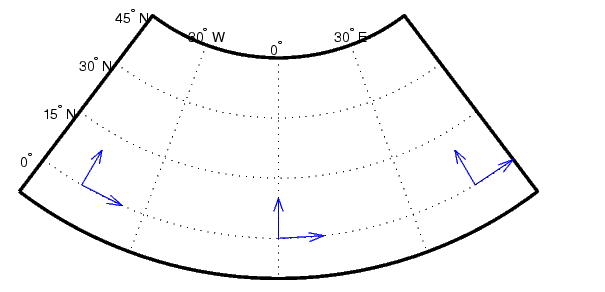
axesm('eqdconic','maplatlim',[-10 45],'maplonlim',[-55 55])
gridm; framem; mlabel; plabel
quiverm([0 0 0],[-45 0 45],[0 0 0],[10 10 10],0)
quiverm([0 0 0],[-45 0 45],[10 10 10],[0 0 0],0)


vfwdtran([0 0 0],[-45 0 45],[0 0 0])
ans =
       59.614           90       120.39

vfwdtran([0 0 0],[-45 0 45],[90 90 90])
ans =
      -30.385    0.0001931       30.386
Limitations
This transformation is limited to the region specified by the frame limits in the current map definition.
Remarks
The geographic azimuth angle is measured clockwise from north. The projection space angle is measured counter-clockwise from the x axis.
This function uses a finite difference technique. The geographic coordinates are perturbed slightly in different directions and projected. A small amount of error is introduced by numerical computation of derivatives and the variation of map distortion parameters.
See Also
vinvtran |
Transforms azimuths from a projection space angle |
mfwdtran |
Process the map forward transformations |
minvtran |
Process the map inverse transformations |
defaultm |
Initializes the default map data structure |
| | vec2mtx | viewshed | |