| Mapping Toolbox | |
Project a 2-D quiver plot onto the current map axes
Activation
| Command Line |
Maptool |
| quiverm |
Map Quiver 2D Quiver 2D |
Description
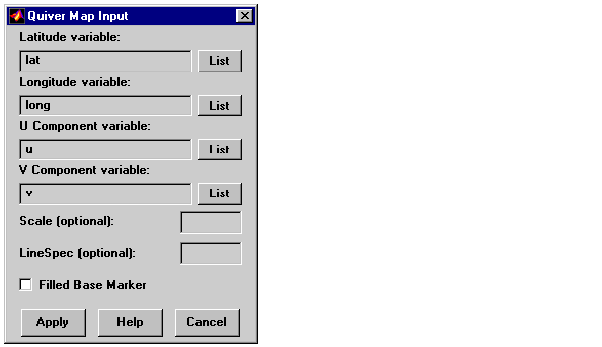
quiverm activates a Quiver Map Input dialog box to project a two-dimensional quiver plot onto the current map axes. Vectors with components (u,v) are displayed at the points (latitude,longitude) on the map.
If no map axes are current, a No Map Axes dialog box appears. Choose Yes to activate the Projection Control dialog box for defining map axes properties. Upon creation of the map axes, the Quiver Map Input dialog box appears.
Controls
The Latitude variable edit box is used to specify the workspace variable containing the latitude data for the quiver plot.
The Longitude variable edit box is used to specify the workspace variable containing the longitude data for the quiver plot.
The U Component variable edit box is used to specify the workspace variable containing the u vector component data.
The V Component variable edit box is used to specify the workspace variable containing the v vector component data.
Pressing the List button produces a list of all current workspace variables, from which the latitude, longitude, u, and v variables can be selected.
The Scale edit box is used to enter the workspace variable containing the scale factor applied to the projected vectors. The vector lengths are automatically determined to make them as long as possible without overlapping. The vector lengths are then multiplied by scale. For example, a scale value of 0.5 results in vectors half as long as they would be with the default scale of 1. A scale of 0 suppresses automatic scaling, and the vector lengths are determined from the inputs. In this case, the vectors are plotted from (latitude,longitude) to (latitude+u,longitude+v). A scalar value for scale can be entered instead of a variable name.
The Linespec edit box is used to enter a line specification, such as '-r*', for the quiver plot. If a symbol is given in the linespec string, it is plotted at the beginning of the vectors. If no symbol is given in the linespec string, arrows are plotted at the end of the vectors.
The Filled Base Marker check box is used to specify a filled-in symbol at the beginning of each vector.
Pressing the Apply button accepts the input data and projects the quiver plot onto the current map axes.
Pressing the Cancel button disregards any input data and closes the Quiver Map Input dialog box.
See Also
quiverm
| | quiver3m | scatterm | |