| Mapping Toolbox | |
Project patch objects on the current map axes
Activation
| Command Line |
Maptool |
| fillm fill3m patchm patchesm |
Map Patch Patch |
Description
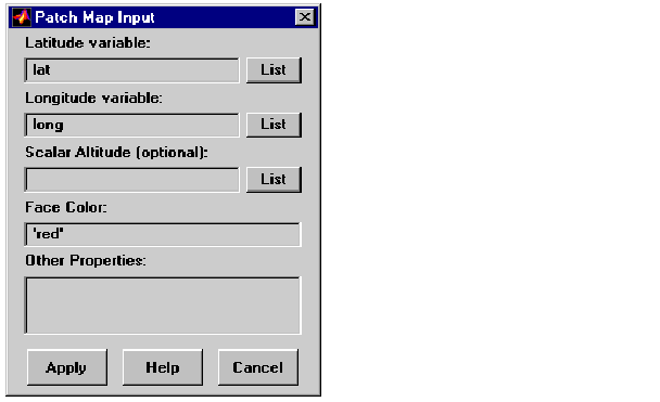
fillm, fill3m, patchm, and patchesm all activate a Patch Map Input dialog box that accepts input data to project a patch object onto the current map axes.
If no map axes are current, a No Map Axes dialog box appears. Choose Yes to activate the Projection Control dialog box for defining map axes properties. Upon creation of the map axes, the Patch Map Input dialog box appears.
Controls
The Latitude variable edit box is used to specify the workspace variable containing the latitude data of the patch object to be projected.
The Longitude variable edit box is used to specify the workspace variable containing the longitude data of the patch object to be projected.
The Scalar Altitude edit box is used to specify a scalar value or scalar workspace variable that determines the plane in which the mapped patch object is to be displayed.
Pressing the List button produces a list of all current workspace variables, from which the latitude, longitude, and altitude variables can be selected.
The Face Color edit box is used to specify the color of the patch face. A valid color string, enclosed in quotes, or an RGB triple enclosed in brackets, can be entered. A workspace variable can also be entered, provided it is a color string or an RGB triple.
The Other Properties edit box is used to specify additional properties of the patch object to be projected, such as 'EdgeColor','none'. String entries must be enclosed in quotes.
Pressing the Apply button accepts the input data and projects the patch object onto the current map axes.
Pressing the Cancel button disregards any input data and closes the Patch Map Input dialog box.
See Also
fillm fill3m patchm patchesm
| | demcmap | handlem | |