| Mapping Toolbox | |
Describe waypoints of a navigational track
Description
Track waypoints put into latitude and longitude column-vectors are said to be in navigational track format. Waypoints are points through which a track passes, usually corresponding to course or speed changes. A navigational track is made up of the line segments connecting these waypoints, which are called legs. In navigational track format, n legs are described using n+1 waypoints.
For Mapping Toolbox navigation functions, angle units are always in degrees. See the section entitled "Conventions for Navigational Functions" in the Mapping Toolbox User's Guide for more information on unit formats for navigation functions.
Examples
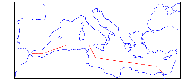
The waypoints of the following track, in navigational track format, are:
waypoints = [36 -5; 36 -2; 38 5; 38 11; 35 13; 33 30; 31.5 32]
waypoints =
   36.0000   -5.0000
   36.0000   -2.0000
   38.0000    5.0000
   38.0000   11.0000
   35.0000   13.0000
   33.0000   30.0000
   31.5000   32.0000
See Also
dreckon |
Compute dead reckoning positions for a track |
gcwaypts |
Find equally-spaced waypoints along a great circle |
legs |
Find courses and distances between waypoints |
navfix |
Mercator-based navigational fixing |
track |
Connect navigational waypoints with track segments |
| | navfix | neworig | |