| Mapping Toolbox | |
Determine Mercator-based navigational fix
Syntax
[latfix,lonfix] = navfix(lat,long,az)
[latfix,lonfix] = navfix(lat,long,range,casetype)
[latfix,lonfix] = navfix(lat,long,az_range,casetype)
[latfix,lonfix] = navfix(lat,long,az_range,casetype,drlat,drlon)
Background
This is a navigational function. As such, it assumes that all latitudes and longitudes are in degrees and all distances are in nautical miles. In navigation, piloting is the practice of fixing one's position based on the observed bearing and ranges to fixed landmarks (points of land, lighthouses, smokestacks, etc.) from the navigator's vessel. In conformance with navigational practice, bearings are treated as rhumb lines and ranges are treated as the radii of circles on a Mercator projection.
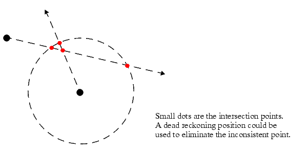
In practice, at least three azimuths (bearings) and/or ranges are required for a usable fix. The resulting intersections are unlikely to exactly coincide. Please refer to the section entitled "Navigation" in the Mapping Toolbox User's Guide for a more complete description of the use of this function.
Description
[latfix,lonfix] = navfix(lat,long,az) returns the intersection points of rhumb lines drawn parallel to the observed bearings, az, of the landmarks located at the points lat and long and passing through these points. One bearing is required for each landmark. Each possible pairing of the n landmarks will generate one intersection, so the total number of resulting intersection points is the combinatorial n choose 2. The calculation time therefore grows rapidly with n.
[latfix,lonfix] = navfix(lat,long,range,casetype) returns the intersection points of Mercator projection circles with radii defined by range, centered on the landmarks located at the points lat and long. One range value is required for each landmark. Each possible pairing of the n landmarks will generate up to two intersections (circles can intersect twice), so the total number of resulting intersection points is the combinatorial 2 times (n choose 2). The calculation time therefore grows rapidly with n. In this case, the variable casetype is a vector of zeroes the same size as the variable range.
[latfix,lonfix] = navfix(lat,long,az_range,casetype) combines ranges and bearings. For each element of casetype equal to 1, the corresponding element of az_range represents an azimuth to the associated landmark. Where casetype is a 0, az_range is a range.
[latfix,lonfix] = navfix(lat,long,az_range,casetype,drlat,drlon) returns for each possible pairing of landmarks only that intersection which lies closest to the dead reckoning position indicated by drlat and drlon. When this syntax is used, all included landmarks' bearing lines or range arc must intersect. If any possible pairing fails, the warning No Fix is displayed.
NaNs are returned in that row.
When a dead reckoning position is included, these matrices will be column vectors.
Examples
For a fully illustrated example of the application of this function, please refer to the "Navigation" section in the Mapping Toolbox User's Guide.
Imagine you have two landmarks, at (15°N,30.4°W) and (14.8°N,30.1°W). You have a visual bearing to the first of 280° and to the second of 160°. Additionally, you have a range to the second of 12 nm. Find the intersection points:
[latfix,lonfix] = navfix([15 14.8 14.8],[-30.4 -30.1 -30.1],...
                         [280 160 12],[1 1 0])
latfix =
   14.9591       NaN
   14.9680   14.9208
   14.9879       NaN
lonfix =
  -30.1599       NaN
  -30.2121  -29.9352
  -30.1708       NaN
Here is an illustration of the geometry:
Limitations
Traditional plotting and the navfix command are limited to relatively short distances. Visual bearings are in fact great circle azimuths, not rhumb lines, and range arcs are actually arcs of small circles, not of the planar circles plotted on the chart. However, the mechanical ease of the process and the practical limits of visual bearing- and navigational radar-ranges (~ 30 nm) make this limitation moot in practice. The error contributed due to these assumptions is minuscule at that scale.
See Also
crossfix |
Great circle fixing |
gcxgc gcxsc scxsc rhxrhpolyxpoly |
Other intersection functions |
| | nanm | navigational track format | |