| Mapping Toolbox | |
Display a regular matrix map warped to a projected graticule
Activation
| Command Line |
Maptool |
| meshm |
Map Regular Surfaces Regular Surfaces |
Description
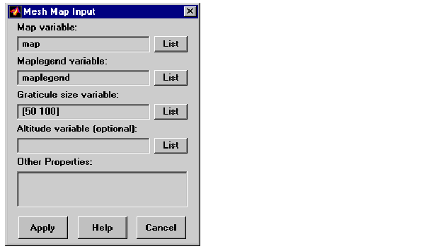
meshm activates a Mesh Map Input dialog box that accepts input data to project a regular surface onto the current map axes.
If no map axes are current, a No Map Axes dialog box appears. Choose Yes to activate the Projection Control dialog box for defining map axes properties. Upon creation of the map axes, the Mesh Map Input dialog box appears.
Controls
The Map variable edit box is used to specify the workspace variable containing the matrix map.
The Maplegend variable edit box is used to specify the workspace variable containing the matrix map legend. Alternatively, a three-element map legend vector enclosed in brackets can be entered in place of a workspace variable.
The Graticule size variable edit box is used to specify the workspace variable containing the graticule resolution. A two-element vector of the form [latitude-points longitude-points] can be entered in place of a workspace variable. The default graticule resolution is [50 100].
The Altitude variable edit box is used to specify the workspace variable containing the altitude data. A scalar value can be entered to specify the z-axis plane in which the graticule mesh is plotted.
Pressing the List button produces a list of all current workspace variables, from which the latitude, longitude, graticule size, and altitude variables can be selected.
The Other Properties edit box is used to specify additional properties of the surface object to be projected, such as 'EdgeColor',[1 1 0]. String entries must be enclosed in quotes. The CData property contains the matrix map and therefore cannot be set by users.
Pressing the Apply button accepts the input data and projects the surface object onto the current map axes.
Pressing the Cancel button disregards any input data and closes the
Mesh Map Input dialog box.
See Also
meshm
| | maptrim | mlayers | |