| Mapping Toolbox | |
Project light objects on the current map axes
Activation
| Command Line |
Maptool |
| lightm |
Map Light Light |
Description
lightm activates a Light Map Input dialog box for projecting a light object onto the current map axes.
If no map axes are current, a No Map Axes dialog box appears. Choose Yes to activate the Projection Control dialog box for defining map axes properties. Upon creation of the map axes, the Light Map Input dialog box appears.
Controls
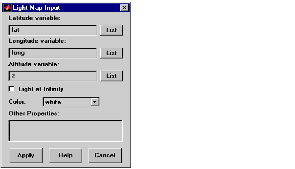
The Latitude variable edit box is used to specify the workspace variable containing the latitude data of the light object to be projected.
The Longitude variable edit box is used to specify the workspace variable containing the longitude data of the light object to be projected.
The Altitude variable edit box is used to specify the workspace variable containing the altitude data of the light object to be projected. A scalar value can be entered to indicate at which height above the map the light object is to be displayed. This entry has no effect if an infinite light source is specified by the Light at Infinity check box.
Pressing the List button produces a list of all current workspace variables, from which the latitude, longitude, and altitude variables can be selected.
The Light At Infinity check box is used to specify a parallel or divergent light source. If the box is checked, the light source is at infinity, in which case the light rays are parallel. If the box is not checked, the altitude of the light source is specified by the altitude variable, and the light rays diverge in all directions. If this box is checked, the altitude variable has no effect.
The Color pull-down menu is used to specify the color of the light coming from the light object. Selecting custom allows a custom RGB triple to be defined.
The Other Properties edit box is used to specify additional properties of the light object to be projected, such as 'Tag','Blue Light'. String entries must be enclosed in quotes.
Pressing the Apply button accepts the input data and projects the lighted object onto the current map axes.
Pressing the Cancel button disregards any input data and closes the Light Map Input dialog box.
See Also
lightm
| | hidem | limitm | |