| Mapping Toolbox | |
Geographic Calculations
Beyond its geographic display capabilities, the Mapping Toolbox also includes an extensive set of commands to analyze geographic data. There are unit conversions and a database of the dimensions of the earth and other heavenly bodies. Other commands include geographical geometry such as distance, azimuth, elevation, reckoning, and intersections. Geographical data such as track lines, circles, ellipses, and buffer zones can also be constructed:
nm2km(1)

ans =

        1.852

sm2km(1)

ans =

       1.6093

dst = distance(45,115,30,135)

dst =

       21.721

deg2km(dst)

ans =

       2415.3

azimuth(45,115,30,135)

ans =

        126.84
Regular matrix maps can also be used in a variety of computations. Matrix map capabilities include inserting or extracting values by geographic location, converting vector to matrix data, coding enclosed regions, and computing the slope, aspect, gradient, and visibility of terrain. For example, here are the water depth and geoid height at a point in the Yellow Sea:
load korea
ltln2val(map,maplegend,35,125)

ans =

   -64

load geoid
ltln2val(geoid,geoidlegend,35,125)

ans =

                     19.7490
In which country is this location?
load worldmtxmed
code = ltln2val(map,maplegend,36,127)

code =

   104

names{code}

ans =

Korea, Republic of
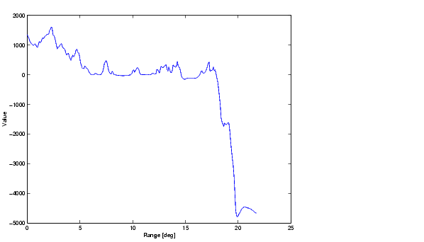
Here is the elevation profile for the Korea elevation data you displayed earlier. The figure shows the elevations and depths along a path from the upper left to the lower right corner of the map:
| | Importing High-Resolution Atlas Data | Getting More Help | |