| Mapping Toolbox | |
Latitude and Longitude
The position of a point on the surface of the Earth, or any other planet, for that matter, can be specified with two angles, latitude and longitude. These angles can be specified in degrees or radians; however, degrees are far more common in geographic usage.
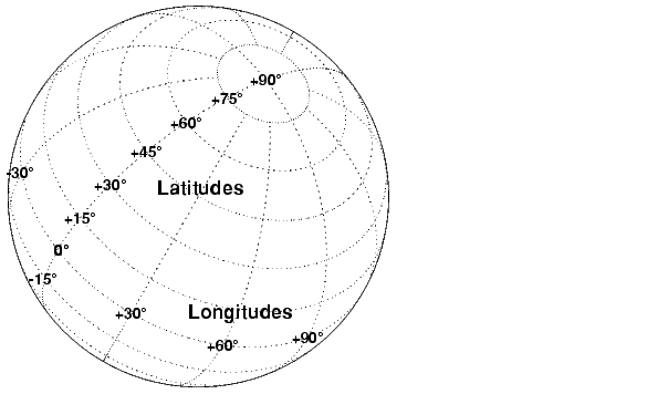
Latitude is the angle at the center of the planet between the plane of the Equator and a line through the center passing through the surface at the point in question. Latitude is positive in the Northern Hemisphere, reaching a limit of +90° at the North Pole, and negative in the Southern Hemisphere, reaching a limit of -90° at the South Pole. Lines of constant latitude are called parallels.
Longitude is the angle at the center of the planet between two planes passing through the center and perpendicular to the plane of the Equator. The first plane also includes the surface point in question; the second plane contains the Prime Meridian, which currently means it includes the point defined by the Royal Observatory in Greenwich, England. Lines of constant longitude are called meridians.
Longitudes ranging from -180° to +180° are unique. Longitudes may be given outside this range, but such values can always be renamed to a value within the range. The Mapping Toolbox provides a number of functions to convert data between different latitude and longitude ranges. For example, the command npi2pi wraps data to this domain:
longitudes = [-560 125 190];
newlongitudes = npi2pi(longitudes)
newlongitudes =
    160.0000  125.0000 -170.0000
Sometimes it is more useful to consider longitude as strictly positive, proceeding from the Prime Meridian (0°) eastward around and back to the Prime Meridian (360°). Any longitude data can be converted to this domain using the zero22pi command:
If you need this data in radians, you can use an angle conversion function:
Several angle conversion functions are available in this toolbox, supporting degrees, radians, and degrees-minutes-seconds notation.
What is the antipodal point (on the opposite side of the Earth) of Natick, Massachusetts (about 42.3°N, 71.35°W)?
The result (42.3°S,108.65°E) lies in the Indian Ocean southwest of Australia.
| | Composite Maps | Great Circles and Rhumb Lines | |