| Mapping Toolbox | |
TIGER/Line
TIGER/Line files are extracts from the U.S. Census Bureau's TIGER map database. Each set of files covers one municipal district and contains transportation features such as roads and railroads, cultural features, hydrographic features, and political boundaries. The data is distributed on CD-ROMs by the Census Bureau. TIGER/Line data is not copyrighted, but the Bureau does charge for the production of the CDs. Ordering and other information can be found from the U.S. Census Bureau's Web site at <http://www.census.gov/>, along with sample TIGER/Line files. CD-ROMs may also be accessible over the Internet through various organizations.
You can import TIGER/Line data into MATLAB using the tgrline function. Files can be several thousand lines long, and reading them may require considerable time and memory. Once the data has been read and processed, you may want to save the results into a MATLAB workspace MAT-file for
future use.
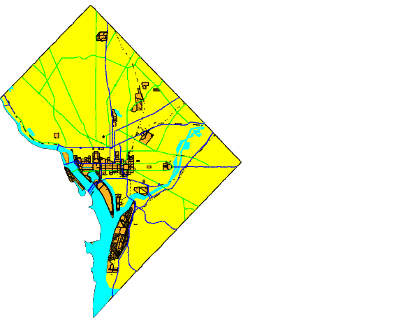
The following example reads the Washington, D.C., data from the 1994 TIGER/Line edition. These files are available over the Internet from The MathWorks at <ftp://ftp.mathworks.com/pub/mathworks/toolbox/map/extMapData/> and are delivered as text files in a compressed PC Zip archive. When extracting, make sure the text files are formatted for your computer platform. Generally, the names of the TIGER/Line datasets begin with the string `tgr' and contain the 5-digit Federal Information Processing Standards (FIPS) code for the state and county.
The dataset for the District of Columbia is `TGR11001':
[CL,PR,SR,RR,H,AL,PL] = tgrline('TGR11001');
whos
The tgrline function returns Mapping Toolbox geographic data structures for the county line (CL), primary roads (PR), secondary roads (SR), railroads (RR), hydrography (H), area landmarks (AL), and point landmarks (PL). This is a subset of the total available data in the TIGER/Line files, which contain more detailed local roads and other geographic reference data, such as Zip codes and census tract numbers, that are not handled by the function.
Since the data is now formatted into geographic data structures, you can display the objects using displaym. A Mercator projection is appropriate for small-scale, regional maps:
axesm mercator
displaym(CL)
hh = displaym(H); set(hh,'EdgeColor','None')
displaym(AL); displaym(PL)
displaym(PR); displaym(SR); displaym(RR)
You can also produce the same map with graphical user interfaces. Using the maptool application, invoke the mlayers tool by selecting Session LayersWorkspace from the menu bar, or invoke mlayers from the command line by typing
 rootlayr; mlayers(ans).
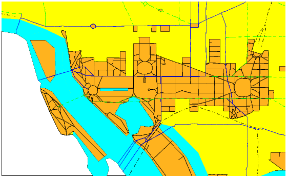
The amount of detail in the data becomes apparent when you zoom into the federal district of Washington, D.C. While the map has much detail, the street patterns contain displaced points, and the number of points in the paths of the streets is not enough to give smooth representations of slowly curving streets.
If you hold down the mouse button on an object, you will see its name appear in the lower left part of the figure window. All objects have been tagged with a name. Here are the names of places in the hydrography layer:
unique(strvcat(H.tag),'rows')

ans =
Anacostia River
Channel
Dalecarlia Reservoir
Georgetown Reservoir
Kenilworth Aquatic Gardens
Kingman Lake
Lagoon
Mc Millan Reservoir
Potomac River
Reflecting Pool
Tidal Basin
Washington Channel
The other layers have tags with street names, interstate highway numbers, railroad names, and landmarks names. The names can be useful in finding the location of a site or in the selective display of data. What is the latitude and longitude of the Washington Monument? Mark the spot:
[lat,long,indx] = extractm(PL,'washington mon');
PL(indx)
ans =
              lat: 38.8891
             long: -77.0354
              tag: 'Washington Monument'
             type: 'line'
         altitude: 0.4000
    otherproperty: {1x3 cell}

h = displaym(PL(indx)); set(h,'Marker','x','Color','r')
You can also use the mobjects tool to browse the names of objects that have already been plotted.
| | U.S. Vector Data | TIGER Thinned Boundary | |