| Mapping Toolbox | |
TIGER Thinned Boundary
The U.S. Census Bureau has published lower resolution, thinned extracts of the TIGER database in two data file formats: ARC/INFO and MapInfo Interchange Format (MIF). ARC/INFO and MapInfo are geographic information systems (GIS) developed by the Environmental Systems Research Institute, Inc. (ESRI) and MapInfo Corporation, respectively. Data files for both formats are provided by the U.S. Census Bureau via the Internet <http://www.census.gov/>, along with further descriptions and documentation.
TIGER ArcInfo Format
The following boundary types are available in the ArcInfo format: state, county, minor civil division, census tract/block numbering area, American Indian reservation/Alaska native village statistical area, Alaska native regional corporation, urbanized area, metropolitan area, and congressional district.
The ArcInfo data files have names ending in `p' and `pa'; the first represents polygon coordinate data, and the latter polygon attributes. You will also need the `_name.dat' file, or names file, containing the FIPS codes and corresponding county names.
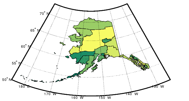
Plot the counties in the state of Alaska as an example. You will need the following three files: `co_name.dat,' `co_02_p.dat,' and `co_02_pa.dat.' For these files, `co' indicates county boundaries, and `02' is the code for Alaska. The code `99' is used for files within the continental United States, and `15' corresponds to Hawaii. The files are compressed in a PC Zip format. When extracting, make sure the text files are formatted for your computer platform.
Read all U.S. county names and FIPS code from the names file. There are more than 3000 entries, so reading the file may take a while:
You can query the FIPS code of a particular city or county in Alaska, Anchorage, for example, by the following commands:
Use the tigerp function to read and process Alaska's thinned county boundaries data into Mapping Toolbox geographic data structures.
Plot the data in a Lambert Conformal Conic projection:
[COpatch,COtext] = tigerp(namestruc,'co_02_p.dat');
axesm('MapProjection','lambert',...
    'MapLatLimit',[50 73],'MapLonLimit',[175 235] ,...
    'MLabelLocation',10,'MLineLocation',10,...
    'PLabelLocation',5,'PLineLocation',5,...
    'MLabelParallel','south','MapParallels',[]);
framem; gridm; mlabel; plabel
displaym(COpatch)
colormap(summer)
There is one entry in the COpatch structure for each county, with the county name in the tag field. The COtext structure contains the text labels for the counties.
You can also append new data to existing structures or extract only the counties you want. The following example reads the county boundaries for Nome and then adds the boundaries for the Aleutians East and Aleutians West to the output structure. You can look in the namestruc structure to find the codes you need.
COpatch = tigerp(namestruc,'co_02_p.dat',[],[],2180);
COpatch = tigerp(namestruc,'co_02_p.dat',COpatch,[],...
                 [2013 2016])
COpatch =
1x3 struct array with fields:
    lat
    long
    type
    otherproperty
    altitude
    tag
TIGER MapInfo Interchange Format
The U.S. Census Bureau provides thinned boundary files in the MapInfo Interchange Format. Both U.S. state and county boundaries are available in this format.
The MapInfo data files have the `mif' and `mid' extensions. You will also need the `_name.dat' file, or names file, containing the Federal Information Processing Standard (FIPS) code numbers and corresponding county names.
The following example reads the state boundaries of Alaska and Hawaii. Five files are needed: `ST02.MID,' `ST02.MIF,' `ST15.MID,' `ST15.MIF,' and `st_name.dat.' You must first read the names file for the names and FIPS codes for the U.S. states and territories:
Read the file containing Hawaii's county boundaries into a geographic data structure, and append it with Alaska's state boundaries:
STpatch = tigermif(namestruc,'ST15.MIF');
STpatch = tigermif(namestruc,'ST02.MIF',STpatch)
STpatch =
1x2 struct array with fields:
    lat
    long
    type
    otherproperty
    tag
    altitude
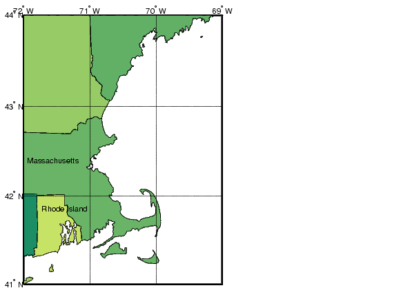
Finally, to compare the resolution and quality of this data to other sources, look at the region around Cape Cod. This map may look familiar to you; it is the same data in the usahi workspace, plotted in a Mercator projection. The usahi data was derived from the Census Bureau's TIGER Thinned Boundary files.
| | TIGER/Line | Global Matrix Data | |