| Mapping Toolbox | |
The Map Grid
In The Mapping Toolbox, the map grid is the set of displayed meridians and parallels. Display the grid by setting the map axes property Grid to 'on'. This can be accomplished upon map axes creation with axesm, with setm, or with the direct command gridm on.
To control display of meridians and parallels, set a scalar meridian spacing or a vector of desired meridians in the MLineLocation property. The corresponding property PLineLocation serves the same purpose for parallels. The default values are every 30° for meridians and every 15° for parallels.
By default, the grid is placed as the top layer of any display. You can alter this by changing the GAltitude property, so that other map objects can be placed "above" the grid. The new grid is drawn at its new altitude.
To reposition the grid back to the top of the display, use the command gridm reset. You can also control the appearance of grid lines with the GLineStyle and GLineWidth properties, which are ':' and 0.5, respectively, by default.
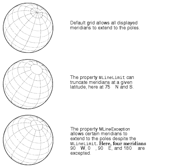
The Miller projection is an example in which all the meridians can extend to the poles without appearing to be cluttered. Look, however, at the following Orthographic projections. When all the meridians extend to the poles, the look is "congested." The MLineLimit property allows you to specify a pair of latitudes at which to terminate the meridians. For example, setting MLineLimit to [-75 75] completely clears the polar region of displayed meridians. Sometimes you might like to allow some of the meridians to ignore the limit and extend to the pole. If, for example, MLineException is set to [-90 0 90 180], then the meridians corresponding to those four longitudes will continue past the limit on to the pole:
There are also corresponding map axes properties for controlling the extent of displayed parallels: PLineLimit and PLineException.
Users can label displayed parallels and meridians. MeridianLabel and ParallelLabel are on-off properties for the display of labels on the meridians and parallels, respectively. They are both 'off' by default. Initially, the label locations coincide with the default displayed grid lines, but you can alter this by using the PlabelLocation and MlabelLocation properties. These grid lines are labeled across the north edge of the map for meridians and along the west edge of the map for parallels. However, the property MlabelParallel allows you to specify 'north', 'south', 'equator', or a specific latitude at which the meridian labels will be displayed, and the PlabelMeridian allows the choice of 'west', 'east', 'prime', or a specific longitude for the parallel labels. By default, parallel labels are displayed in the range of 0° to 90° north and south of the Equator while Meridian labels are displayed in the range of 0° to 180° east and west of the Prime Meridian. You can use the mlabelzero22pi function to re-display the Meridian labels in the range of 0° to 360° east of the Prime Meridian. For complete descriptions of all map axes properties, refer to the axesm reference page in the online Mapping Toolbox reference documentation.
| | The Map Frame | Map and Frame Limits | |