| Mapping Toolbox | |
The Map Frame
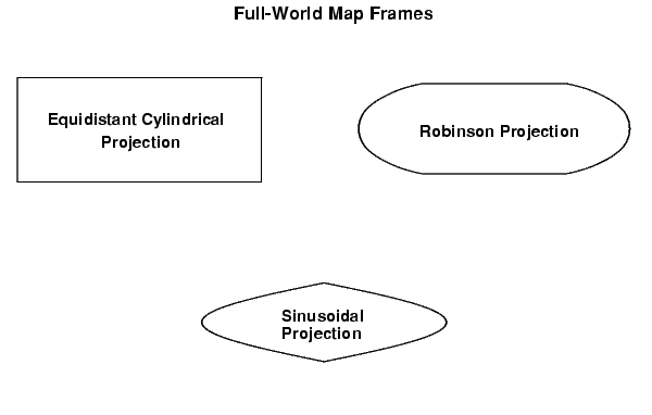
In the Mapping Toolbox, the map frame is a box enclosing the geographic display. The frame is displayed if the map axes property Frame is set to 'on'. This can be accomplished upon map axes creation with axesm, with setm, or with the direct command framem on. The frame is geographically defined as a latitude-longitude quadrangle that is projected appropriately. For example, on a map of the world, the frame might extend from pole to pole and a full 360° in longitude. In appearance, the frame would take on the characteristic shape of the projection. The examples below are full-world frames shown in three very different projections:
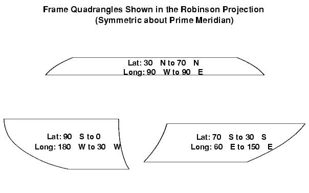
As a map object, each of the previously displayed frames is identical; however, the selection of a display projection has varied their appearance. Since each of the examples shows the entire world, FLatLimit is [-90 90], and FLonLimit is [-180 180] for each case. The frame quadrangle can encompass smaller regions, as well:
For the frames shown above, the projection is centered on the Prime Meridian, or 0 longitude. Such a frame would be the result of creating a map axes with the defaults for the Robinson projection and then resetting the frame limits to cover just part of the world.
For example, to view the asymmetric frame in the lower right of the previous figure, type:
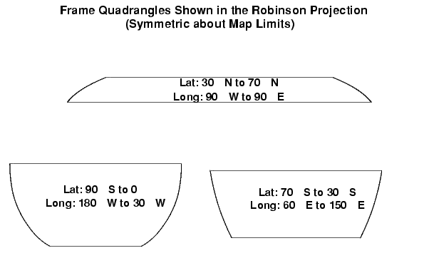
When you want your frame to be symmetric about the region of interest, have axesm determine the proper settings for you. If you specify the map limits without specifying the map origin and frame limits, axesm will automatically set the appropriate values for a proper symmetric frame.
For example, to view the symmetric frame in the lower right of the previous figure, set the map limits with axesm:
axesm('MapProjection','robinson',...
     'MapLatLimit',[-70 -30],...
     'MapLonLimit',[60 150],...
     'Frame','on')
In addition to the latitude and longitude limits of the frame, other properties can be manipulated. The frame is actually a patch with a default face color set to 'none' and a default edge color of black. These map axes properties can be altered by manipulating the FFaceColor and FEdgeColor properties. For example, the command:
can make the background region of your display resemble water. Since the frame patch is always the lowest layer of a map display, other patches, perhaps representing land, will appear above the "water." If an object is subsequently plotted "below" the frame patch, the frame altitude can be recalculated to lie below this object with the command framem reset. The frame is replaced and not reprojected.
The line width of the edge, which is 2 points by default, can be set using the FLineWidth property.
The primary advantage of displaying the map frame is that it can provide positional context for other displayed map objects. For example, when vector data of the coasts is displayed, the frame provides the "edge" of the world.
In addition to establishing frame properties upon map axes creation, or through the setm command, you can use the framem command. The command framem alone is a toggle for the Frame property, which controls the visibility of the frame. You can also call framem with property names and values to alter the appearance of the frame:
| | Accessing and Manipulating Map Axes Properties | The Map Grid | |