| Mapping Toolbox | |
Choropleth Maps
A common type of map display has patch faces colored proportional to some specified data. The data generally represents the value of something per unit area, such as population density, electoral votes, or incidence of disease. Maps of this type are generally called choropleth maps. It is easy to construct choropleth maps with MATLAB and the Mapping Toolbox. Simply assign the data values to the CData property of the displayed patches.
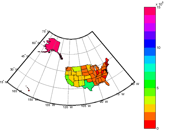
In the following example, patches representing the 50 states of the U.S. (and the District of Columbia) are displayed and colored according to the surface areas calculated by the areaint function. An equal-area projection is appropriate for this kind of display.
load usalo
axesm('MapProjection','eqaconic','MapParallels',[],...
      'MapLatLimit',[15 75],'MapLonLimit',[-175 -60],...
      'MLineLocation',15,'MLabelParallel','south',...
      'MeridianLabel','on','ParallelLabel','on',...
      'GLineStyle','-','GColor',0.5*[1 1 1],...
      'Grid','on','Frame','on')
displaym(state)

geoid = almanac('earth','geoid');
tags = {state.tag};
for i=1:length(state)
      lat = state(i).lat; long = state(i).long;
      surfarea = sum(areaint(lat,long,geoid));
      set(handlem(tags{i}),'CData',surfarea);
end

caxis([0 1.5E6])
colormap(hsv(15))
colorbar
The coloring scheme of the map makes it easy to distinguish which states are comparable in area. The color scale to the right of the map shows the surface areas in square kilometers:
The largest state is Alaska (about 1.5 million square kilometers), while Rhode Island stands as the smallest state (about 2500 square km). The District of Columbia, of course, is the smallest entity of the dataset, at roughly 200
square km.
| | North Arrows | Thematic Map Functions | |