| Mapping Toolbox | |
Geoid
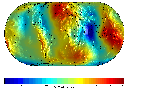
While the topo matrix contains the heights and depths of the Earth's crust, the geoid matrix gives the shape of its gravitational field. The geoid can be regarded as the ocean surface formed in the absence of waves, currents, tides, and land obstructions. In technical terms, it is a gravitational equipotential surface. Elsewhere, this document refers to the ellipsoidal shape of the Earth as the geoid. Although this is sufficient for cartography, the ellipsoidal approximation is not accurate enough for applications like surveying and geodesy, and more detailed models are used. The EGM96 geoid model is a widely used spherical harmonic model of the geoid complete to degree and order 360. A 1-degree grid of geoid heights is provided in the geoid.mat atlas file. The full resolution version of the matrix of geoid heights with a grid spacing of 15 minutes can be read using the egm96geoid external interface function described in External Data Interface.
load geoid
figure; axesm eckert4; framem; gridm

plotm(coast,'k')
zdatam(handlem('line'),max(geoid(:)))
meshm(geoid,geoidlegend,size(geoid),geoid,'Facecolor','interp')
light; material(0.6*[ 1 1 1])

set(gca,'dataaspectratio',[ 1 1 200])
hcb = colorbar('horiz')
set(get(hcb,'Xlabel'),'String','EGM96 geoid heights in m.')
Interpolating the full resolution grid gives a result that is about half a meter higher.
| | Terrain | United States Vector Data | |