| Mapping Toolbox | |
Terrain
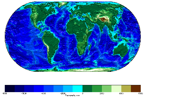
A low resolution set of global elevation data is provided with MATLAB in the topo workspace. It is a regular matrix of average elevations and depths (in meters) for a constant grid spacing of one degree by one degree.
load topo
whos
|
|
|
|
|
|
|
|
topo |
180x360 |
518400 |
|
topolegend |
1x3 |
24 |
|
topomap1 |
64x3 |
1536 |
|
topomap2 |
128x3 |
3072 |
|
Here it is displayed in an equal-area Eckert IV projection as a shaded-relief surface, which allows both large and small features to be seen:
axesm eckert4; framem; gridm
plotm(coast,'k'); zdatam(handlem('line'),max(topo(:)))
meshm(topo,topolegend,size(topo),topo,'FaceColor','interp')
demcmap('inc',topo,1000)
camlight(0,80);; material([0.7 0.8 .4]); daspectm('m',300)
hcb = colorbar('horiz')
set(get(hcb,'XLabel'),'String','Topography in m.')
| | World Matrix Data | Geoid | |