| Mapping Toolbox | |
Conventions for Navigational Functions
Units
The Mapping Toolbox is, in general, very flexible in allowing a variety of angular and distance measurement units. To make the strictly navigational functions easy to handle and to conform to common navigational practice, for these specific functions, angles are always in degrees, distances are always in nautical miles, and speeds are always in knots (nautical miles per hour). The functions for which these conventions hold are dreckon, gcwaypts, legs, and navfix. Related functions that do not carry this restriction include rhxrh, scxsc, gcxgc, gcxsc, track, timezone, and crossfix, because of their potential for application outside of navigation.
Navigational Track Format
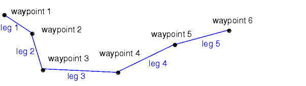
Navigational track format requires column-vector variables for the latitudes and longitudes of track waypoints. A waypoint is a point through which a track passes, usually corresponding to a course (or speed) change. Navigational tracks are made up of the line segments connecting these waypoints, which are called legs. In this format, therefore, n legs are described using n+1 waypoints, because an endpoint for the final leg must be defined.
Here, five track legs require six waypoints. In navigational track format, the waypoints would be represented by two 6-by-1 vectors, one for the latitudes and one for the longitudes.
| | Navigation | Fixing Position | |