| Aerospace Blockset |
  |
WGS84 Gravity Model
Implement the 1984 World Geodetic System (WGS84) representation of Earth's gravity
Library
Environment/Gravity
Description
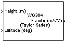
The WGS84 Gravity Model block implements the mathematical representation of the geocentric equipotential ellipsoid of the World Geodetic System (WGS84). The block output is the Earth's gravity at a specific location. Gravity precision is controlled via Type of gravity model.
The WGS84 Gravity Model block icon displays the input and output units selected from the Units pop-up menu.
Dialog Box
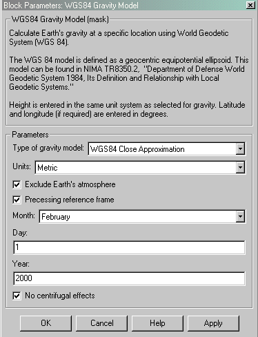
- Type of gravity model
- Specifies the method to calculate gravity:
- WGS84 Taylor Series
- WGS84 Close Approximation
- WGS84 Exact
- Units
- Specifies the input and output units:
|
Height
|
Gravity
|
Metric
|
Meters
|
Meters per second squared
|
English
|
Feet
|
Feet per second squared
|
- Exclude Earth's atmosphere
- When selected, the value for the Earth's gravitational field excludes the mass of the atmosphere.
- If cleared, the value for the Earth's gravitational field includes the mass of the atmosphere.
- This option is only available with Type of gravity model WGS84 Close Approximation or WGS84 Exact.
- Precessing reference frame
- When selected, the angular velocity of the Earth is calculated using the International Astronomical Union (IAU) value of the Earth's angular velocity and the precession rate in right ascension. In order to obtain the precession rate in right ascension, Julian Centuries from Epoch J2000.0 is calculated using the dialog parameters of Month, Day, and Year.
- If cleared, the angular velocity of the Earth used is the value of the standard Earth rotating at a constant angular velocity.
- This option is only available with Type of gravity model WGS84 Close Approximation or WGS84 Exact.
- Month
- Specifies the month used to calculate Julian Centuries from Epoch J2000.0.
- This option is only available with Type of gravity model WGS84 Close Approximation or WGS84 Exact and only when Precessing reference frame is selected.
- Day
- Specifies the day used to calculate Julian Centuries from Epoch J2000.0.
- This option is only available with Type of gravity model WGS84 Close Approximation or WGS84 Exact and only when Precessing reference frame is selected.
- Year
- Specifies the year used to calculate Julian Centuries from Epoch J2000.0. The year must be 2000 or greater.
- This option is only available with Type of gravity model WGS84 Close Approximation or WGS84 Exact and only when Precessing reference frame is selected.
- No centrifugal effects
- When selected, calculated gravity is based on pure attraction resulting from the normal gravitational potential.
- If cleared, calculated gravity includes the centrifugal force resulting from the Earth's angular velocity.
- This option is only available with Type of gravity model WGS84 Close Approximation or WGS84 Exact.
Inputs and Outputs
The first input is a vector containing altitudes in specified length units.
The second input is a vector containing latitudes in degrees.
The third input is a vector containing longitudes in degrees. This input is only available with Type of Gravity Model WGS84 Close Approximation or WGS84 Exact.
The output is a vector containing gravities in specified acceleration units.
Assumptions and Limitations
The WGS84 gravity calculations are based on the assumption of a geocentric equipotential ellipsoid of revolution. Since the gravity potential is assumed to be the same everywhere on the ellipsoid, there must be a specific theoretical gravity potential that can be uniquely determined from the four independent constants defining the ellipsoid.
Use of the WGS84 Taylor Series model should be limited to low geodetic heights. It will be sufficient near the surface when sub-microgal precision is not necessary. At medium and high geodetic heights, it will be less accurate.
Use of the WGS84 Close Approximation model should be limited to a geodetic height of 20000.0 m (approximately 65620.0 ft). Below this height, it will give results with sub-microgal precision.
References
[1] NIMA TR8350.2: "Department of Defense World Geodetic System 1984, Its Definition and Relationship with Local Geodetic Systems."
| | Velocity Conversion | | Wind Shear Model | |