| Mapping Toolbox | |
Project Tissot indicatrices onto map axes
Syntax
h = tissot
h = tissot(spec)
h = tissot(spec,linestyle)
h = tissot(spec,PropertyName,PropertyValue,...)
h = tissot(spec,linestyle,PropertyName,PropertyValue,...)
h = tissot(linestyle)
h = tissot(PropertyName,PropertyValue,...)
h = tissot(linestyle,PropertyName,PropertyValue,...)
Background
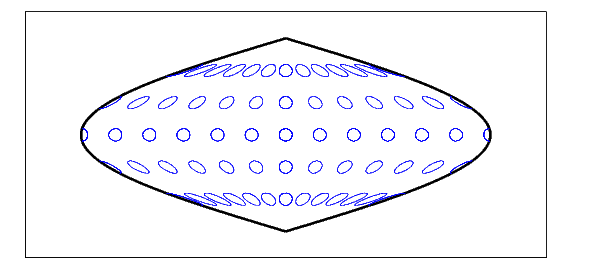
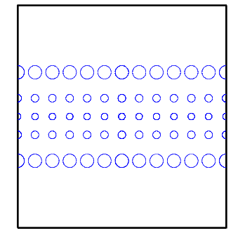
Tissot indicatrices are plotting symbols, which are useful for understanding the various distortions of a given map projection. The indicatrices are circles of identical true radius on the Earth's surface. When plotted on a map projection, they indicate whether the projection has certain features. If the plotted indicatrices all enclose the same area, the projection is equal area (for example, a Sinusoidal projection would have this feature). If they all remain circular, then conformality is indicated (a Mercator projection has this property). Distortions in meridianal or parallel distance are exhibited by flattened or stretched indicatrices. Many projections will show very even, circular indicatrices in some regions, often near the center, and wildly distorted indicatrices in others, such as near the edges. The Tissot diagram is therefore very useful in analyzing the appropriateness of a projection to a given purpose or region. Projections Reference of this guide includes Tissot diagrams for every projection on a global scale.
Description
The general layout of the Tissot diagram is defined by the specification vector spec.
spec = [Radius]spec = [Latint,Longint]spec = [Latint,Longint,Radius]spec = [Latint,Longint,Radius,Points]
Radius is the small circle radius of each indicatrix circle. If entered, it should be in the same units as the map axes Geoid. The default radius is 1/10th the radius of the sphere.
Latint is the latitude interval between indicatrix circle centers. If entered it should be in the map axes AngleUnits. The default value is one circle every 30º of latitude (i.e. 0°,+/-30°, etc.).
Longint is the longitude interval between indicatrix circle centers. If entered it should be in the map axes AngleUnits. The default value is one circle every 30º of latitude (i.e. 0°,+/-30°, etc.).
Points is the number of plotting points per circle. The default is 100 points.
h = tissot plots the default Tissot diagram, as described above on the current map axes and returns handles for the displayed indicatrices.
h = tissot(spec) allows you to specify plotting parameters of the displayed Tissot diagram as described above.
h = tissot(spec,linestyle) specifies any linestyle string recognized by the standard MATLAB function line to set the line style of the Tissot indicatrices.
h = tissot(spec,PropertyName,PropertyValue,...) allows the specification of any property and value recognized by the line command.
Examples
The Sinusoidal projection is equal area.
The Mercator projection is conformal.
See Also
mdistort |
Display contours of constant distortion on a map |
distortcalc |
Calculate distortion parameters for a map projection |
projections |
See Projections Reference |
| | timezone | track | |