| Mapping Toolbox | |
Project text on the current map axes
Activation
| Command Line |
Maptool |
| textm |
Map Text Text |
Description
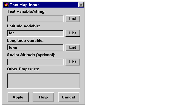
textm activates a Text Map Input dialog box, which accepts input data to project a text object onto the current map axes.
If no map axes are current, a No Map Axes dialog box appears. Choose Yes to activate the Projection Control dialog box for defining map axes properties. Upon creation of the map axes, the Text Map Input dialog box appears.
Control
The Text variable/string edit box is used to specify the workspace variable containing the text strings to be projected. A single text string can also be entered, provided it is enclosed in single quotes. Multiple lines of text can be entered using a cell array.
The Latitude variable edit box is used to specify the workspace variable containing the latitude data for the text string(s) to be projected. If a single text string is to be plotted, a scalar latitude value can be entered.
The Longitude variable edit box is used to specify the workspace variable containing the longitude data of the text object(s) to be projected. If a single text string is to be plotted, a scalar longitude value can be entered.
The Scalar Altitude edit box is used to specify the workspace variable containing the z-axis altitudes of the text object(s) to be projected. If a single text string is to be plotted, a scalar altitude value can be entered.
Pressing the List button produces a list of all current workspace variables, from which the latitude, longitude, and altitude variables can be selected.
The Other Properties edit box is used to specify additional properties of the text object(s) to be projected, such as 'FontSize',12. String entries must be enclosed in quotes.
Pressing the Apply button accepts the input data and projects the text object(s) onto the current map axes.
Pressing the Cancel button disregards any input data and closes the Text Map Input dialog box.
See Also
textm
| | tagm | trackui | |