| Mapping Toolbox | |
Display a lighted matrix map warped to a projected graticule
Activation
| Command Line |
| surflm |
Description
surflm activates a Surflm Map Input dialog box to project a lighted map surface onto the current map axes.
If no map axes are current, a No Map Axes dialog box appears. Choose Yes to activate the Projection Control dialog box for defining map axes properties. Upon creation of the map axes, the Surflm Map Input dialog box appears.
Controls
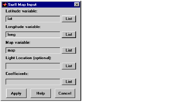
The Latitude variable edit box is used to specify the workspace variable containing the latitude data of the surface to be projected.
The Longitude variable edit box is used to specify the workspace variable containing the longitude data of the surface to be projected.
The Map variable edit box is used to specify the workspace variable containing the matrix map.
The Light Location edit box is used to specify the workspace variable containing the direction of the light source. This can be a three-element vector of the form [x y z] or a two-element vector of the form [azimuth elevation]. If omitted, the default is 45 degrees counterclockwise from the current view direction.
The Coefficients edit box is used to specify the workspace variable containing the relative contributions of ambient light, diffuse reflection, specular reflection, and the specular shine coefficient. This is a four-element vector of the form [ka kd ks shine]. If the entry is omitted, the default is [.55 .6 .4 10].
Pressing the List button produces a list of all current workspace variables, from which the latitude, longitude, map, light location, and coefficient variables can be selected.
Pressing the Apply button accepts the input data and projects the lighted surface object onto the current map axes.
Pressing the Cancel button disregards any input data and closes the Surflm Map Input dialog box.
See Also
surflm
| | surfdist | tagm | |