| Mapping Toolbox | |
Project a stem plot onto the current map axes
Activation
| Command Line |
Maptool |
| stem3m |
Map Stem Stem |
Description
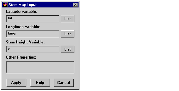
stem3m activates a Stem Map Input dialog box for projecting a stem plot onto the current map axes. A stem plot displays data as lines extending perpendicular to the xy-plane on the map.
If no map axes are current, a No Map Axes dialog box appears. Choose Yes to activate the Projection Control dialog box for defining map axes properties. Upon creation of the map axes, the Stem Map Input dialog box appears.
Controls
The Latitude variable edit box is used to specify the workspace variable containing the latitude coordinates for the stem plot.
The Longitude variable edit box is used to specify the workspace variable containing the longitude coordinates for the stem plot.
The Stem Height variable edit box is used to specify the workspace variable containing the stem height data.
Pressing the List button produces a list of all current workspace variables, from which the latitude, longitude, and stem height variables can be selected.
The Other Properties edit box is used to specify additional properties of the stem lines to be projected, such as 'Color','r'. String entries must be enclosed in quotes.
Pressing the Apply button accepts the input data and projects the stem plot onto the current map axes.
Pressing the Cancel button disregards any input data and closes the Stem Map Input dialog box.
See Also
stem3m
| | showm | surfdist | |