| Mapping Toolbox | |
Compute coordinates of a small circle path from center and perimeter point
Syntax
pts = scircle2(lat1,lon1,lat2,lon2)
[latc,lonc] = scircle2(lat1,lon1,lat2,lon2)
[latc,lonc] = scircle2(lat1,lon1,lat2,lon2,units)
[latc,lonc] = scircle2(lat1,lon1,lat2,lon2,geoid)
[latc,lonc] = scircle2(lat1,lon1,lat2,lon2,geoid,units)
[latc,lonc] = scircle2(lat1,lon1,lat2,lon2,geoid,units,npts)
[latc,lonc] = scircle2(track,lat1,,lon1,lat2,lon2...)
Background
A small circle is the locus of all points an equal surface distance from a given center. For true small circles, this distance is always calculated in a great circle sense; however, the scircle2 command allows a locus to be calculated using distances in a rhumb line sense as well. An example of a small circle is all points exactly 100 miles from the Washington Monument.
Description
[latc,lonc] = scircle2(lat1,lon1,lat2,lon2) returns the coordinates of points along small circles centered at the points provided in lat1 and lon1, which pass through the points provided in lat2 and lon2. The coordinates of multiple small circles are stored in separate columns of latc and lonc.
[latc,lonc] = scircle2(lat1,lon1,lat2,lon2,units) specifies the units for the inputs and outputs, where units is any valid angle units string. The default value is 'degrees'.
[latc,lonc] = scircle2(lat1,lon1,lat2,lon2,geoid) specifies the elliptical definition of the Earth to be used with the two-element geoid vector. The default geoid model is the sphere, which is sufficient for most applications.
[latc,lonc] = scircle2(lat1,lon1,lat2,lon2,geoid,units,npts) specifies the number of output points, npts, returned per small circle. The default value of npts is 100.
[latc,lonc] = scircle2(track,lat1,lon1,lat2,lon2...) specifies the logic with which ranges are calculated. If the string track is 'gc' (the default), great circle distance is used. It track is 'rh', rhumb line distance is used.
pts = scircle2(lat1,lon1,lat2,lon2) returns the points in a two-column output pts.
Examples
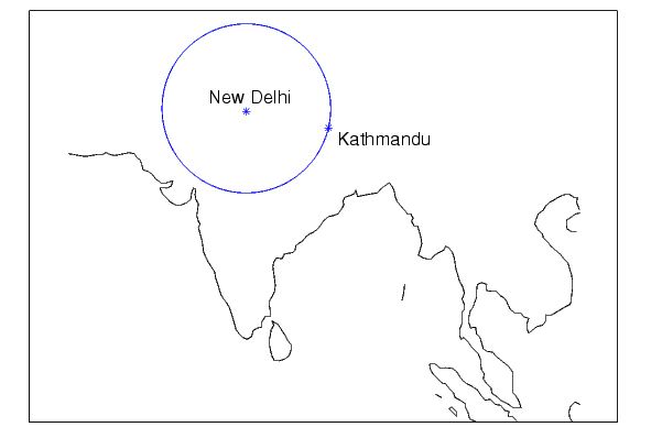
Plot the locus of all points the same distance from New Delhi as Kathmandu:
axesm('mercator','MapLatlimit',[0 40],'MapLonLimit',[60 110]);load coastplotm(lat,long,'k'); % For reference lat1 = 29; lon1 = 77.5; % New Delhi lat2 = 27.6; lon2 = 85.5; % Kathmanduplotm([lat1 lat2],[lon1 lon2],'b*') % Plot the cities[latc,lonc] = scircle2(lat1,lon1,lat2,lon2); plotm(latc,lonc,'b')
See Also
scircle1 |
Small circle from center and radius |
track |
Connect waypoints with track segments |
track1track2 |
Great circles and rhumb lines |
| | scircle1 | scircleg | |