| Mapping Toolbox | |
The Geoid Model
Although the Earth is round, it is not exactly a sphere. However, for many users and most applications, the difference is so small that a spherical assumption is sufficient. This section addresses how the Mapping Toolbox handles more accurate models of the shape, or figure, of the Earth and other planets.
What Is a Geoid?
Literally, geoid means Earth-shaped. The geoid is the precise figure of the Earth. Specifically, it is an equipotential surface with respect to gravity. It is approximately an oblate ellipsoid, but not exactly so because of local variations in gravity.
For the purposes of map display, the geoid of the Earth is assumed to be an exact ellipsoid. This is a simplification of the precise definition of geoid; however, it is a good approximation, which allows a great variety of calculations to be performed that would otherwise be prohibitively complicated. Ellipsoidal models of the Earth's figure are considered sufficient for cartography. The use of the term geoid for this ellipsoid is perhaps peculiar to the toolbox. Further, in the Mapping Toolbox, the term geoid is extended to ellipsoidal models for the figures of the Sun, Moon, and planets.
For purposes other than map display, a more detailed model of the figure of the Earth is used. For more information on detailed geoid models, see Atlas Data and External Data Interface.
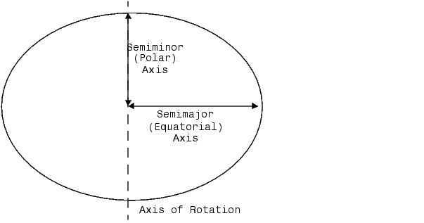
The Geoid Vector
Since the toolbox treats the geoid as an ellipsoid, the geoid can be described with a two-element vector, which is often called the geoid vector in this guide. The geoid vector has the form [semimajor-axis eccentricity]. The semimajor axis can be in any unit of distance; the choice of these units often drives the units used for distance outputs in the toolbox functions.
An ellipsoid is defined as a rotation of an ellipse around its minor axis. Ellipses can be defined with a semimajor and a semiminor axis, flattening, the parameter n, or the preferred method of a semimajor axis and eccentricity. The toolbox has functions to convert elliptical definitions from any of these forms to the form of the geoid vector. For example, the command axes2ecc returns an eccentricity when given the semimajor and semiminor axes.
The geoid vector, along with several other kinds of planetary data for each of the planets and the Earth's moon, can be queried using the almanac function provided by the Mapping Toolbox (see Measuring the Planets).
For the Earth, the semimajor axis is about 21 kilometers longer than the semiminor axis. Use the almanac function to verify this:
geoid = almanac('Earth','geoid','kilometers') geoid = semiminor = minaxis(geoid) semiminor = geoid(1) - semiminor ans = 21.38
When compared to the semimajor axis, which is almost 6400 kilometers, this difference seems insignificant and can be neglected for most purposes. For this reason, most functions in the Mapping Toolbox default to a spherical model of the Earth. The ellipse in the previous diagram is very exaggerated. The difference between the semimajor and semiminor axes of a correct ellipse at this scale would be far smaller than the width of the line used to draw it.
What Is the "Correct" Geoid Vector?
A variety of ellipsoid models have been proposed through the years. They differ because of the surveying information upon which they are based, or because certain regions of interest of the true geoid are best modeled by a particular ellipsoid that may be less accurate for other parts of the world. The Mapping Toolbox default geoid vector (after the sphere) is based on the 1980 Geodetic Reference System ellipsoid. This geoid vector is returned by the statement almanac('Earth','geoid'). It is also the reference ellipsoid for the 1984 World Geodetic System equipotential model.
Several other geoid vectors are supported, for models ranging from Everest's 1830 ellipsoid (used for India) to the International Astronomical Union ellipsoid of 1965 (used for Australia). These can be referenced by the following statements:
The reference page for the almanac function has more information on which geoids are available.
You should probably use a spherical Earth unless you have a good reason to use an ellipsoidal model. If you use an ellipsoidal model, you should probably use the default unless you need a specific one. If you cannot find the geoid vector you need, you can create it in the following form:
Note that the default units for the geoid semimajor axis in the almanac function are kilometers, which can be used by simply passing in an empty matrix in place of the input units string, as in the previous example. Eccentricity is dimensionless.
| | Measuring Area | Measuring the Planets | |