| Mapping Toolbox | |
USGS On-Line Coastline Extractor
There is also an on-line source for a variety of coastline data. The U. S. Geological Survey has a Web page that allows you to extract coastlines, political boundaries, rivers, and lakes for a selected quadrangle, and download the data in a MATLAB compatible text file. You can extract data from the NOAA/NOS Medium Resolution Coastline (U. S. coverage only, designed for a scale of 1:70,000), the World Vector Shoreline (designed for 1:250,000), the CIA World Data Bank II (designed for 1:2,000,000), and the World Coast Line (designed for 1:5,000,000). The location of the Web page is
<http://crusty.er.usgs.gov/coast/getcoast.html>
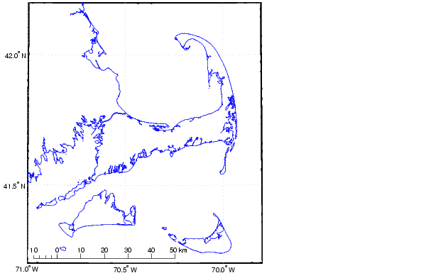
Here is the NOAA/NOS Medium Resolution Coastline for Cape Cod. The data was saved in the file, 15162.dat.
load 15162.dat
whos
  Name         Size         Bytes  Class

  X15162   21087x2         337392  double array

usamap([41.2 42.2],[-71 -69.8],'none')
plotm(X15162(:,2),X15162(:,1)); scaleruler
| | Global Self-Consistent Hierarchical High-Resolution Shoreline | U.S. Vector Data | |