| Mapping Toolbox | |
The Graticule
The Mapping Toolbox projects surface objects in a manner very similar to the traditional methods of map making. The cartographer traditionally lays out a grid of meridians and parallels, called the graticule. Each graticule cell is therefore a geographic quadrangle. The cartographer calculates the appropriate x-y locations for every vertex in the graticule grid and draws the projected graticule by "connecting the dots." Finally, the cartographer draws the map data in "freehand," attempting to account for the shape of the graticule cells. Similarly, the Mapping Toolbox calculates the x-y locations of the four vertices of each graticule cell and warps the matrix data to fit the resulting quadilateral.
In the toolbox, as in traditional cartography, the finer the graticule mesh
(i.e., the more meridians and parallels used), the greater the precision of the projected map display, at the cost of greater effort and time. Graticules for regular matrix maps are defined in the toolbox as a two-element vector, of the form [number-of-parallels, number-of-meridians]. For general matrix maps, the graticule is related to the size of the latitude and longitude coordinate matrices, where number-of-parallels=mrows-1 and number-of-meridians=ncols-1.
While the graticule cell for a regular matrix map is restricted to equal-angle quadrangles (i.e., length of cell in latitude must equal length of cell in longitude), general matrix maps have no such constraint. Their graticule cells can be of any size.
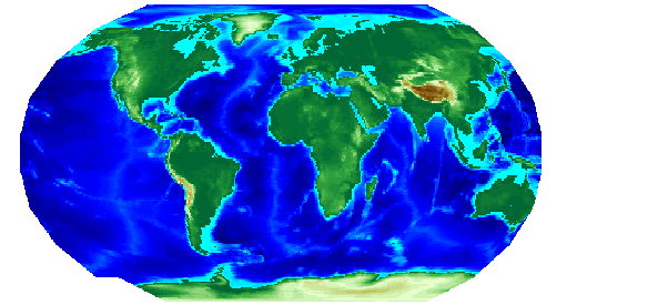
The topo regular matrix map can be displayed quickly using a coarse graticule. The cost is in precision:
load topo
figure; axesm robinson
graticule = [10 20];
h = meshm(topo,topolegend,graticule);
demcmap(topo)
Notice that for this coarse graticule, the edges of the map do not appear as smooth curves. What may not be as obvious is that the easternmost column of graticule cells and the southwesternmost cell are sometimes invisible on displayed matrix maps. This is necessary for the proper projection of the surface object and is not a concern except with the coarsest graticules. Previous displays used the default [50 100] graticule, for which this effect is negligible.
Regardless of the graticule resolution, the matrix map data is unchanged. In this case, the matrix map is the 180-by-360 topo matrix, and regardless of projection fidelity, the resolution of its value data is unchanged.
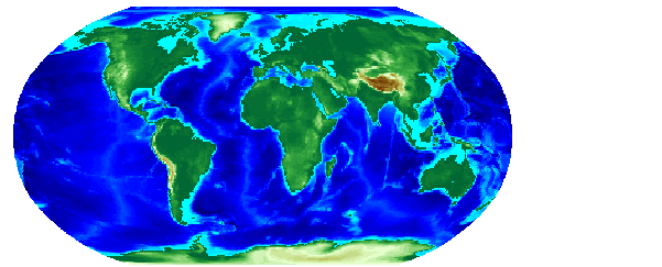
Map objects displayed as surfaces have all the properties of any MATLAB surface, which can be set at object creation or by using the MATLAB set command. The mapping setm command allows the MeshGrat graticule property to be manipulated for regular matrix surfaces. Since you saved the handle of the last displayed map, reset its graticule to a very fine grid. Remember, the trade-off is between resolution and time, so this could take a while:
You'll probably notice that the result does not appear to be any better than the original display with the default [50 100] graticule, but it took much longer to produce. Actually, the 200-by-400 graticule grid is finer than the 180-by-360 data resolution. There is really no reason to ever use a graticule finer than your data. In practice, you will probably find that coarse graticules are good for development tasks and fine graticules serve well for final graphics production.
| | Displaying Matrix Maps | Data Representation | |